Hello and welcome back to the ohsome Region of the Month-blog post series where you can read about potential use cases of the ohsome API and maybe even get inspired…
OpenStreetMap (OSM) is a global mapping project which generates free geographical information through a community of volunteers. OSM is used in a variety of applications and for research purposes. However,…
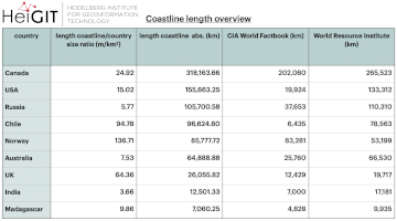
The ohsome region of the month blog post series is back and since it’s summer this time we’re taking you to the coast. Before that happens, if this is your…
Slums are an important operational area for humanitarian organisations: Because of provisional housing, poor sanitation and difficult socio-political circumstances offers of help from such organisations are important and often necessary….
In 2020, the Humanitarian OpenStreetMap Team (HOT) received funding from seven donors through TED’s Audacious Project. This has accelerated HOT’s ambition to map an area home to one billion people….
The AGILE 2021 conference is taking place this week. It is the the 24rd AGILE conference on GIScience. AGILE is the Association of Geographic Information Laboratories in Europe and the…
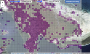
Accurate and complete geographic data of human settlement is crucial for humanitarian aid and disaster response. OpenStreetMap (OSM) can serve as a valuable source, especially for global south countries where…
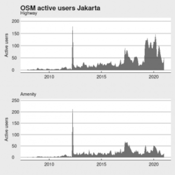
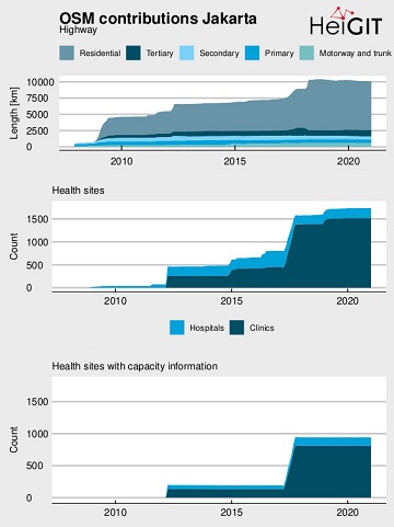
Data quality is an important issue then performing analysis based on OpenStreetMap data. We have recently demonstrated how the effects of the 2013 flood in Jakarta on the accessibility of…
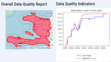
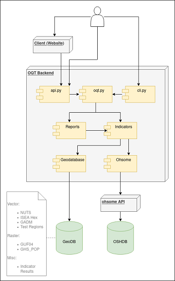
The ohsome quality analyst (short: OQT) has been introduced at the beginning of this year and today we are proud to announce two updates. First, we released the new version…
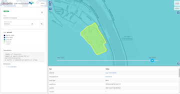
Did you ever wonder how your city was mapped over time, how geometries were changed and refined, how mistakes were added and corrected again? Then read on: ohsomeHex has a…
Welcome back to our blog post series ”ohsome Region of the Month” where you can find information on potential applications of the ohsome API. If you’re new to this format…
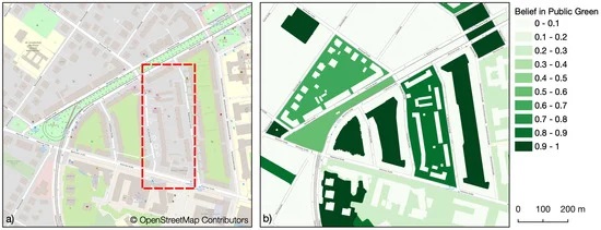
Public urban green spaces are important for the urban quality of life. Still, comprehensive open data sets on urban green spaces are not available for most cities. As open and…
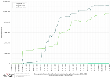
Welcome back to the ohsome region of the month format where you can learn and get inspiration about potential applications of the ohsome API. This time we looked at forest-related…
As a little Easter present, we published the first version of the ohsome-py Python package today. ohsome-py helps you extract and analyse OpenStreetMap history data using the ohsome API and…
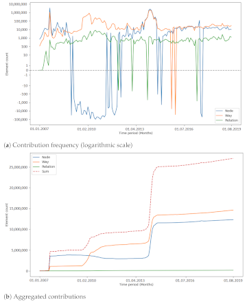
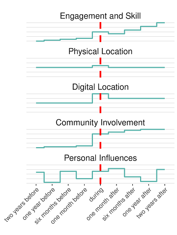
Online knowledge projects such as OpenStreetMap (OSM) and Wikipedia have gained high importance, trust and even economic value. These projects and their content are maintained and enhanced by online communities…
The #ohsome quality analyst (short: OQT) has been online and accessible through its web-interface now for quite some weeks already (see the introductory blog post as a reference). The website…
Extreme natural events create catastrophic situations for cities and their populations. Due to climate change and anthropogenic activities, the number and intensity of these events has steadily increased at the…
HeiGIT wants to serve you better. Therefore we are conducting user feedback surveys regarding our various services. The Deadline has been extended to March 05rd! Take your chance! If you…
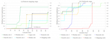
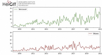
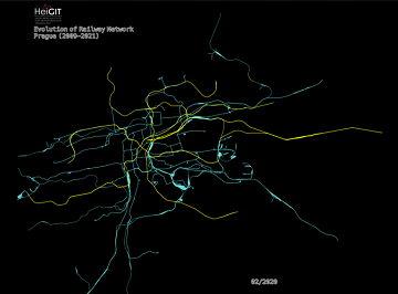
Welcome back to another #ohsome blog post written by our awesome student assistent Sarah! This time we will look at the completeness of railway network data of one specific city…
HeiGIT wants to serve you even better. Therefore we are conducting user feedback surveys regarding our various services. If you have ever used one of our OpenStreetMap based Online Services…