
On May 15th, the Program of Scientific Computing (PROCC) at Fiocruz hosted Steffen Knoblauch, a GIScience Ph.D. candidate, for his presentation titled “GeoAI 4 Dengue: Harnessing Geospatial Big Data to Guide Vector Control.” This event, organized in partnership with The … Read More
Blog
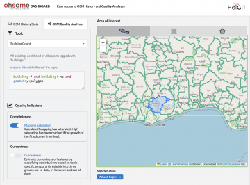
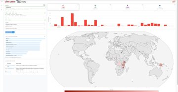
ohsome Quality API: New Features
Are you ready to take your OpenStreetMap (OSM) data analysis to the next level? We’re excited to showcase the latest features of our ohsome Dashboard, designed to provide you with insights into OSM data quality. With the ohsome Dashboard, analyzing … Read More
HGG (Heidelberger Geographische Gesellschaft) Lecture Series in Summer Semester 2024
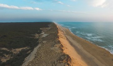
Coasts are highly dynamic and multifunctional border areas between land and sea. According to the United Nations, more than a third of the world’s population lives less than 100 km from the nearest coast. They fulfill crucial functions for nature … Read More
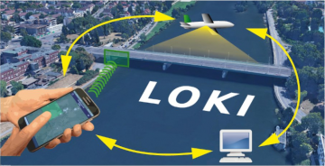
The LOKI Project: Rapid Earthquake Damage Assessment
In the aftermath of earthquakes, rapid and accurate assessment of infrastructure damage is crucial. The LOKI project (Airborne Observation of Critical Infrastructures), funded by the Federal Ministry for Education and Research and active from January 1, 2020, to March 31, … Read More

Impact Day: Waterproofing Data – Engaging Stakeholders in Sustainable Flood Risk Governance for Urban Resilience
Join us at Impact Day on May 15th in the foyer of the Neue Universität, organized by the Heidelberg University! The event will showcase the university’s knowledge and technology transfer, spotlighting projects across four focal areas: socially relevant, industrial, sustainable … Read More

HeiGIT at the AGILE 2024 Conference: Mapping, Routing, Sustainability
“Geographic Information Science for a Sustainable Future” – The theme of this year’s conference held by the Association of Geographic Information Laboratories in Europe (AGILE) in Glasgow, UK, on 4-7 June 2024. Attendees of the AGILE 2024 conference will explore … Read More
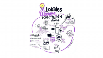
German Conference on Disaster Risk Reduction – Mapping Local Knowledge with the Sketch Map Tool
The 2024 Fachtagung Katastrophenvorsorge (Disaster Risk Reduction Symposium) centered around the theme “On the Edge? Disaster risk reduction in uncertain times.” Held in a hybrid format on April 22 and 23 at the Tagungswerk Berlin, this conference served as a … Read More
Mapping Progress in Real Time: Highlights from GeoNight 2024 Mapathon with HeiGIT and Mannheimer Mapathons
During GeoNight 2024, HeiGIT partnered with Mannheimer Mapathons to host a mapathon together. Mapathons are events where volunteers come together to map crucial features like roads, buildings or waterways on OpenStreetMap, often in response to specific needs or crises, such … Read More
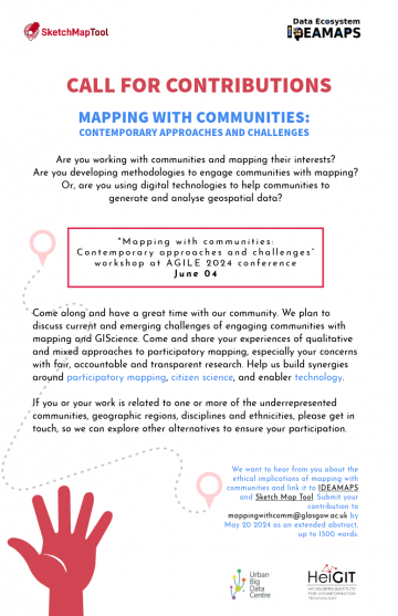
Call for contributions
Excited to announce the CALL FOR CONTRIBUTIONS! Are you passionate about mapping with communities? Join us at the “Mapping with communities: Contemporary approaches and challenges” workshop at AGILE 2024 conference on June 04. Share your experiences, methodologies, and digital innovations … Read More
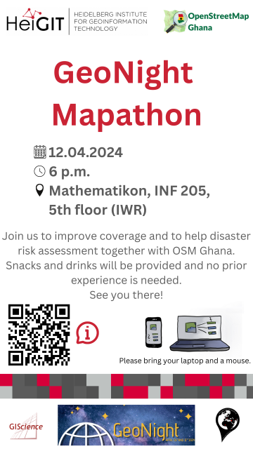
GeoNight Mapathon
Our next Mapathon is just around the corner, and this time, we’re joining forces with OpenStreetMap Ghana to improve coverage and to help disaster risk assessment. Join us and be a part of the GeoNight 2024 to celebrate geography together in … Read More
“How to assess the needs of vulnerable population groups towards heat-sensitive routing?”
The research team of the transdisciplinary project HEAL (Heat Adaptation for Vulnerable Population Groups), focusing on providing heat adaptation measures for vulnerable groups in Heidelberg, has published a research paper titled “How to assess the needs of vulnerable population groups … Read More
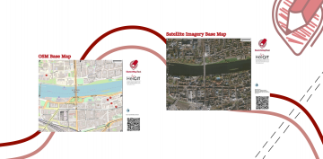
Unveiling the Sketch Map Tool 2.0: A Comprehensive Overview of New Features and Training Opportunities
The HeiGIT gGmbH (Heidelberg Institute for Geoinformation Technology) team has just released a version 2.0 of the Sketch Map Tool, a low-tech solution for participatory sketch mapping through offline data collection, digitization and georeferencing of local spatial knowledge. Thanks to continuous … Read More
HeiGIT at FOSSGIS 2024
We’re proud to share our recent conference experience with you! Our HeiGIT Product Owners for Big Data and Smart Mobility, Benjamin Herfort and Julian Psotta, had the privilege of attending the FOSSGIS 2024 conference, where they contributed valuable insights and … Read More
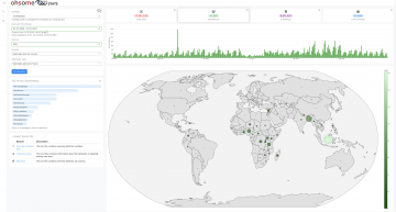
Introducing ohsomeNow stats v1.0
OhsomeNow stats makes it possible to monitor contributions to OpenStreetMap (OSM) in real time. We developed this new dashboard as part of our long-term cooperation with the Humanitarian OpenStreetMap Team (HOT), an international organization dedicated to humanitarian action and community … Read More
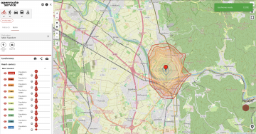
Introducing openrouteservice version 8.0 — A dedication to Wilfried Juling
We’re thrilled to announce the release of openrouteservice (ors) version 8.0, designated “Wilfried”, as a tribute to Prof. Dr. Wilfried Juling, whose steady support and advice fundamentally shaped the growth and success of HeiGIT since its beginning. With countless hours … Read More
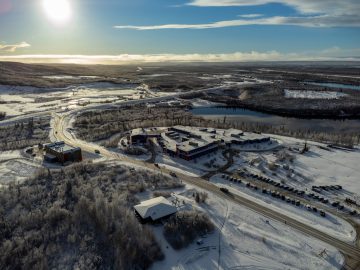
Chasing Permafrost: Insights from the Aklavik Expedition
In 2022, we embarked on an insightful expedition to Aklavik, Canada, in collaboration with our partners, the Alfred Wegener Institute (AWI) Helmholtz Center for Polar and Marine Research and the German Aerospace Center (DLR). This joint effort within the UndercoverEisAgenten … Read More

Call for Applications – Robert and Christine Danziger Scholarship 2024
The Robert and Christine Danziger Scholarship application window is open until August 31st, 2024, offering a unique opportunity for doctoral candidates from Africa, particularly Ghana or West and Central Africa. The scholarship designed for those pursuing a doctorate at Heidelberg … Read More
Job Opening: Head of Administration (f/m/d)
Are you interested in applying your experience and knowledge to support science-related, non-profit organizations for the betterment of society and the environment? If so, we have a compelling and fitting position for you! HeiGIT gGmbH is a research-oriented, non-profit company … Read More
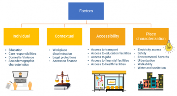
Empowering Change: OpenRouteService in Geospatial Initiatives for Women’s Economic Empowerment and Sustainable Development
The use of open-source geospatial data, exemplified by services like openrouteservice (ORS), proves to be beneficial for both academic research and use case studies. Witnessing our technologies applied in unanticipated ways showcases their potential to meet the evolving needs of … Read More
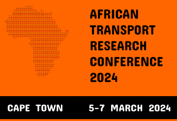
Unveiling the Impact of School Commutes: Charles Hatfield Presents Insights on Traffic Congestion and Urban Planning at ATRC 2024
Charles Hatfield will represent HeiGIT at the first ever African Transport Research Conference (ATRC 2024) which takes place from March 5-7 in Capetown, South Afrika. The conference was established to address rapid urbanisation in Africa and the corresponding challenges for … Read More