Welcome back to our Region of the Month series. If you’re hearing about this format the first time you should definitely check out some of our older blog posts, e.g….
At long last, welcome back to out Region of the Month-series, where we look at different regions in the world and how tags are used there. Today we would like…
Hello and welcome back to part 12 of our “How to become ohsome“-blog post series! If you’re new to this series, check out other blog posts of the series as…
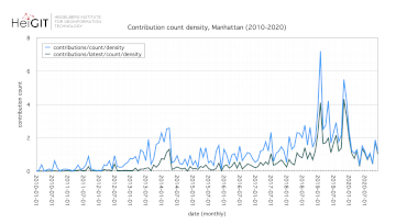
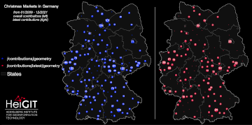
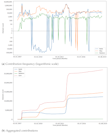
Working with OpenStreetMap data is an exciting topic that often reveals astonishing insights. The free and open nature of the project allows a plethora of analyses topics. We at HeiGIT…
Hello and welcome back to the How to become ohsome-blog series! We hope the new year started off well for you! If you’re new to the series, you should read…
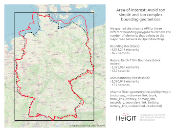
Welcome back to our blog post series How to become ohsome, where you get short and simple explanations on how you can become ohsome yourself! This time, it’s all about…
In the context of the United Nations World Data Forum 2021 organised by theUnited Nations Statistics Division and UN member states a series of blogposts has been published by UNSTATS….
Einladung Vortrag Online: Dienstag, 14. Dezember 2021, 19:15 Uhr Melanie Eckle-Elze, Benjamin Herfort, Dr. Carolin Klonner Digitale Geographie im Katastrophenmanagement Klimawandel, Bevölkerungswachstum, Verstädterung und weitere zunehmende Landnutzungsveränderungen führen dazu, dass…
At long last, welcome back to a new blog post of the “How to become ohsome“-series. As it’s been quite a while since you got an introduction to how to…
Recently videos with our contributions by HeiGIT to the FOSS4G conference were put online. Did you miss the event? Now you can watch whenever you like 🙂 Benni by HeiGIT…
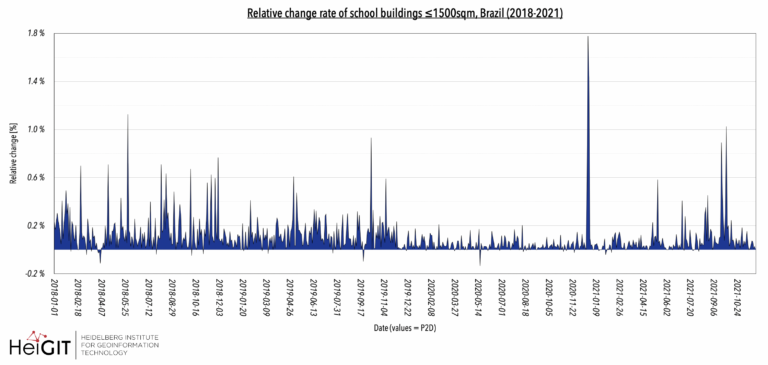
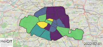
Hello and welcome back to another blog post of the ohsome Region of the Month series where you can learn about potential use cases of the ohsome API. This month…
In 2020, the Humanitarian OpenStreetmap Team (HOT) was selected for The Audacious Project, a collaborative philanthropic initiative that serves as a springboard for social impact on a grand scale. This…
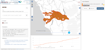
On the 19th of September 2021 a volcanic eruption on the Canary Island of La Palma started. Since then the resulting lava field is constantly growing and continues its destructive…
Last week, the annual conference FOSS4G (Free and Open Source Software for Geospatial) has been taken place online. The conference is organized by The Open Source Geospatial Foundation (OSGeo) and…
Hello and welcome back to the ohsome Region of the Month-blog post series where you can read about potential use cases of the ohsome API and maybe even get inspired…
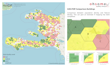
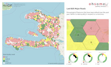
OpenStreetMap (OSM) is a global mapping project which generates free geographical information through a community of volunteers. OSM is used in a variety of applications and for research purposes. However,…
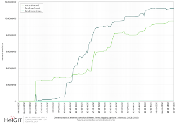
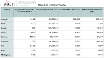
The ohsome region of the month blog post series is back and since it’s summer this time we’re taking you to the coast. Before that happens, if this is your…
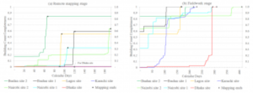
Slums are an important operational area for humanitarian organisations: Because of provisional housing, poor sanitation and difficult socio-political circumstances offers of help from such organisations are important and often necessary….
In 2020, the Humanitarian OpenStreetMap Team (HOT) received funding from seven donors through TED’s Audacious Project. This has accelerated HOT’s ambition to map an area home to one billion people….
The AGILE 2021 conference is taking place this week. It is the the 24rd AGILE conference on GIScience. AGILE is the Association of Geographic Information Laboratories in Europe and the…