A couple of viruses are of global interest with respect to human health and well-being. These pathogens include the novel coronavirus SARS-CoV-2, Dengue, Chikungunya, Yellow fever, Zika and Ebola. These viruses show interesting spatio-temporal dynamics. Improved understanding of the driving … Read More
Blog
MapAction and HeiGIT partner to further geoinformation innovation
The Heidelberg Institute for Geoinformation Technology (HeiGIT) and the international humanitarian geospatial charity MapAction have signed a Memorandum of Understanding (MoU) outlining their plans to collaborate in a number of areas. Both organisations share a common vision to support humanitarian … Read More
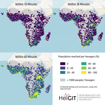
All countries of Sub-Saharan Africa now in Open Healthcare Access Map
Last month we started the Open Healthcare Access Map. Initially, only a few countries were featured. Gradually, more countries and regions are now being added. Today we release all countries of Sub-Saharan Africa. The web application is available here: https://apps.heigit.org/healthcare_access/. … Read More
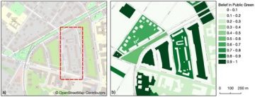
Mapping Public Urban Green Spaces Based on OpenStreetMap and Sentinel-2 Imagery Using Belief Functions
Public urban green spaces are important for the urban quality of life. Still, comprehensive open data sets on urban green spaces are not available for most cities. As open and globally available data sets, the potential of Sentinel-2 satellite imagery … Read More
Two-part Mapathons for better new user retention?
The project “25 Mapathons“ goes into the next phase. Based on the experience of until today 17 OSM mapathons with German Red Cross (GRC) chapter and an extensive literature review on the success of mapathons, the “25 Mapathons” team has … Read More
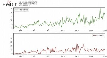
Ohsome Green Region of the Month
Welcome back to the ohsome region of the month format where you can learn and get inspiration about potential applications of the ohsome API. This time we looked at forest-related information in four different Canadian regions looking for the green … Read More
Towards a framework for the analysis of local OSM contributions
Volunteered Geographic Information (VGI) such as OpenStreetMap (OSM) is often defined as the collaborative acquisition of geographic information and local knowledge by volunteers, amateurs or professionals (Goodchild, 2007). The increasing availability and importance of local data in OSM is largely … Read More
SocialMedia2Traffic – Kick-Off presentation 13.04.21
Up-to-date traffic information is a prerequisite for navigation solutions to determine the best route and travel time. In the SocialMedia2Traffic project by HeiGIT and GIScience Heidelberg , conclusions about current traffic density and speed will be derived based on data … Read More
HeiGIT und DRK veröffentlichen weiteres Trainingsmaterial zu Mapathons
Gemeinsam mit dem Deutschen Roten Kreuz (DRK) hat das HeiGIT heute das Dokument “Die häufigsten Fehler beim „mappen“ mit dem iD-Editor & deren Lösung” veröffentlicht. Das Dokument ist komplementär zum Handbuch zur Veranstaltung von Mapathons, welches bereits 2020 veröffentlicht wurde. … Read More
German Mass Vaccination Sites in Open Healthcare Access Map
Last week we introduced Open Healthcare Access Map. Our new web application for interactively sharing results of accessibility estimates based on OpenStreetMap healthcare facilities and openrouteservice isochrones. A new update now shows motorized accessibility estimates of mass vaccination sites in … Read More
ohsome-py: Python Package for OSM history analytics published
As a little Easter present, we published the first version of the ohsome-py Python package today. ohsome-py helps you extract and analyse OpenStreetMap history data using the ohsome API and Python. It handles queries to the ohsome API and converts … Read More
Mapathon “Mapping for International Solidarity” on 06.04
Hello dear friends of the disastermappers heidelberg! At the moment, the Heidelberg International Weeks against Racism 2021 are running – and the disastermappers are also taking part! Why? The unequal distribution of resources is often a consequence of historical (and … Read More
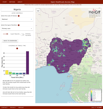
Introducing the Open Healthcare Access Map
Open Healthcare Access Map is a new web application by HeiGIT to provide insights into healthcare supply on different spatial scales for many countries worldwide. The web application is available here: https://apps.heigit.org/healthcare_access/. Please note that this is a prototype and … Read More
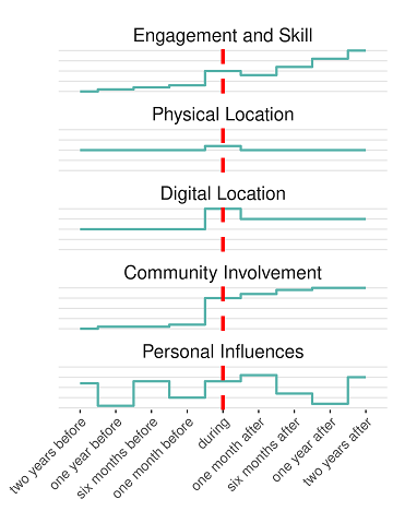
New publication on the Impact of Community Happenings in OpenStreetMap
Online knowledge projects such as OpenStreetMap (OSM) and Wikipedia have gained high importance, trust and even economic value. These projects and their content are maintained and enhanced by online communities that evolve around them. Yet, these communities and their members … Read More
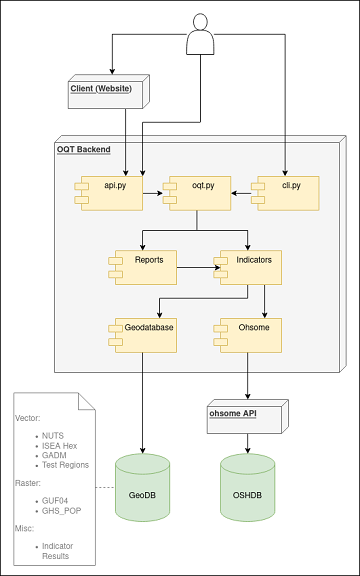
Behind the scenes of the ohsome quality analyst (OQT)
The #ohsome quality analyst (short: OQT) has been online and accessible through its web-interface now for quite some weeks already (see the introductory blog post as a reference). The website is not the only access point to the OQT though. … Read More
Open Position @ HeiGIT: Software Engineer OSM Routing Services – Backend & Algorithms
Sie lieben Open-Source-Geoinformationsdienste zu entwickeln, die täglich von Tausenden genutzt werden? Sie sind ein hochmotivierter Java Backend-Entwickler und Algorithmen-Designer? Und Sie wollen OpenStreetMap für leistungsstarke GI-Dienste mit globaler Abdeckung einsetzen und verbessern? Dann haben wir vielleicht einen passenden und interessanten … Read More
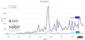
Humanitarian OSM Stats: How to monitor humanitarian mapping in the HOT Tasking Manager? – Part 5: the American Red Cross
Since 2010 organized humanitarian mapping has evolved as a constant and growing element of the global OpenStreetMap (OSM) community. With more than 8,000 projects in 150 countries humanitarian mapping has become a global community effort. Due to this large amount … Read More
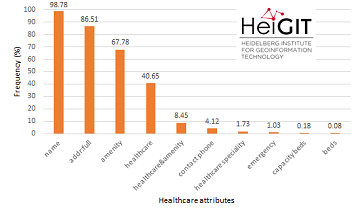
Insights into OpenStreetMap healthcare attributes in India over time
Last November, we covered the recent increase of healthcare related objects in OpenStreetMap (OSM) in India. In less than a year, the amount of facilities has increased from 6.956 to 48.101. This is mainly due to an import run by … Read More

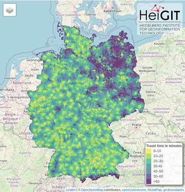
Projektstart von SocialMedia2Traffic – Ableitung von Verkehrsinformationen aus Social–Media-Daten
Aktuelle Verkehrsinformationen sind die Voraussetzung für Navigations-Lösungen, um die beste Route und Fahrzeit zu bestimmen. Es gibt jedoch keine frei verfügbaren Verkehrsinformationen auf weltweiter- und Bundesebene. „SocialMedia2Traffic nutzt frei verfügbare Daten aus sozialen Medien wie zum Beispiel Twitter-Nachrichten“, sagt Prof. … Read More
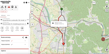
A fresh new ORS maps client
We are happy to announce that the new openrouteservice maps client has been finished and released. It is an open source route planner with plenty of features for car, heavy vehicles, hiking, cycling and wheelchair, designed to be mobile friendly … Read More