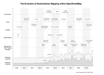
Since 2010 organized humanitarian mapping has evolved as a constant and growing element of the global OpenStreetMap (OSM) community. With more than 7,000 projects in 150 countries humanitarian mapping has become a global community effort. Due to this large amount … Read More
Deutsch
The evolution of humanitarian mapping within the OpenStreetMap community
In the past 10 years, the collaborative maps of OpenStreetMap (OSM) have been used to support humanitarian efforts around the world as well as to fill important data gaps for implementing major development frameworks such as the Sustainable Development Goals … Read More
Humanitarian OSM Stats: How to monitor humanitarian mapping in the HOT Tasking Manager? – Part 2
Since 2010 organized humanitarian mapping has evolved as a constant and growing element of the global OpenStreetMap (OSM) community. With more than 7,000 projects in 150 countries humanitarian mapping has become a global community effort. Due to this large amount … Read More
Vortrag zu Humanitärem Mapping in OpenStreetMap bei Begabtenförderung des Heidelberger Life‐Science Lab
Das Heidelberger Life‐Science Lab ist eine Einrichtung des Deutschen Krebsforschungszentrums (DKFZ, Heidelberg) und hat die Förderung mathematisch und naturwissenschaftlich-technisch besonders interessierter und begabter Mittel- und Oberstufenschüler und Studenten zur Aufgabe. Der Schwerpunkt ist auf die Life-Sciences gerichtet, die den Standort … Read More
Humanitarian OSM Stats: How to monitor humanitarian mapping in the HOT Tasking Manager? – Part 1
Since 2010 organized humanitarian mapping has evolved as a constant and growing element of the global OpenStreetMap (OSM) community. With more than 7,000 projects in 150 countries humanitarian mapping has become a global community effort. Due to this large amount … Read More
Erstes Handbuch zur Veranstaltung von Mapathons im Deutschen Roten Kreuz
Das Handbuch zur Veranstaltung von Mapathons im Deutschen Roten Kreuz (DRK) ist da! In dem Handbuch wird beschrieben, was bei der Durchführung eines Mapathon zu beachten ist. Es beginnt mit der Frage, was überhaupt ein Mapathon ist und erklärt warum … Read More
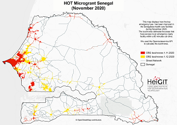
Updated OSM Healthcare in Senegal (2020)
OpenStreetMap (OSM) offers many possibilities and holds potential in the area of freely available infrastructure data for the health sector. Nevertheless, it is important to underline that the quality of the information is different in each country, since the mapping … Read More
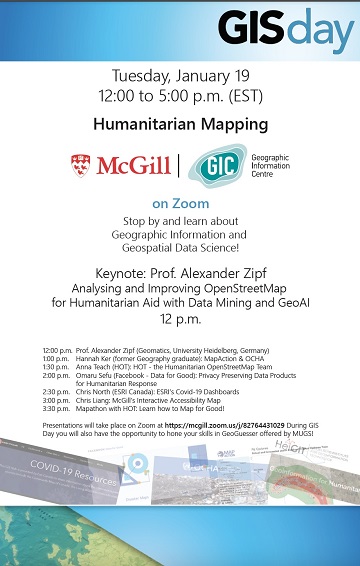
Keynote at McGILL GIS DAY: Analysing and Improving OpenStreetMap for Humanitarian Aid with Data Mining and GeoAI
Prof. Alexander Zipf has been invited to give the keynote at GIS DAY 2021 at McGILL University (Montréal, Canada) on Tuesday 19. Jan. 2021. The theme of the whole GIS Day at McGill is Humanitarian Mapping and the talk will … Read More
Disastermappers Heidelberg International Mapathon on December 8th
On December 8th at 6.30 pm the next international mapathon organized by the disastermappers heidelberg takes place! This time we map together with MAMAPA, an integration project for migrants and refugees from Mannheim, CartONG, LECLARA Larabanga and OSM Ghana. We … Read More
New Jupyter Notebook: Analysis of Access to Health Care using openrouteservice Isochrones API
What is the idea behind the Notebook? In the case of an emergency (e.g. floods, earthquakes, political crisis) it is important to know where the health facilities are located. Furthermore, it is important to identify which cities/districts have a reduced … Read More
Mapathons im Rahmen der OSM Geography Awareness Week – OSM GeoWeek
Kooperation ist in der Humanitären Hilfe oft der Schlüssel, um Menschen in Not schnell und effizient helfen zu können. Das gilt insbesondere beim Austausch von Informationen und Kartenmaterial. Besonders herausfordernd sind die Situationen für Humanitäre Organisationen in Gebieten, von denen … Read More
One step forward for “25 Mapathons” – today Online Mapathon at Humanitarian Congress
The project “25 Mapathons” made an important step forward by successfully completing the first four Mapathons of the project. Two Mapathons were conducted with German Red Cross (GRC) members from the Red Cross Regional association of Westfalen-Lippe. Another two Mapathons … Read More
disastermappers on Tour – Mapathon im Verschwörhaus Ulm + virtuell
Über die letzten Jahre wurden von der OpenStreetMap Community in Ulm vermehrt Mapathons und Mappingaktionen veranstaltet. Am Donnerstag, den 1. Oktober 2020 ab 19:00 Uhr ist ein weiterer Mapathon des Ulmer OSM-Stammtisches geplant – mit Unterstützung von Melanie Eckle-Elze (disastermappers … Read More
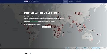
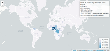
Introducing the humstats.heigit.org dashboard about Humanitarian Mapping in OpenStreetMap
Since 2010 organized humanitarian mapping has evolved as a constant and growing element of the global OpenStreetMap (OSM) community. With more than 7,000 projects in 150 countries humanitarian mapping has become a global community effort. Mappers have added more than … Read More

Einführung in OpenStreetMap und humanitäres Mapping bei der AGIT 2020
HeiGIT unterstützt Workshops zu OpenStreetMap und humanitärem Mapping auf der AGIT 2020 In dieser Woche findet die jährliche AGIT-Konferenz und das parallele GI Forum statt. Während die Konferenz bereits seit mehr als 30 Jahren erfolgreich Vertreter aus Wissenschaft, angewandter Forschung … Read More
Invitation to GIScience colloquium talks related to Humanitarian Aid
We are happy to annouce two higly interesting upcomming presentations in the GIScience colloquium in the next weeks. Everybody interested is invited to join the presentations and the discussion afterwards. The use of geoinformatics at the German Red Cross Katharina … Read More