Zusammen mit dem kolumbianischen Roten Kreuz (CRC), der nationalen Universität Kolumbiens in Manizales (UNAL) und dem UBDC, hat HeiGIT am 29. September 2024 in Cartagena, Kolumbien die IDRiM 2024 veranstaltet. Die Konferenz fand erstmalig in Süd Amerika statt und verzeichnete … Read More
Deutsch

Impact Day: Waterproofing Data – Engaging Stakeholders in Sustainable Flood Risk Governance for Urban Resilience
Join us at Impact Day on May 15th in the foyer of the Neue Universität, organized by the Heidelberg University! The event will showcase the university’s knowledge and technology transfer, spotlighting projects across four focal areas: socially relevant, industrial, sustainable … Read More

„Waterproofing Data“ Projekt gewinnt den ESRC Celebrating Impact Prize 2023
Das „Waterproofing Data“ project hat den ESRC Celebrating Impact Prize 2023 gewonnen. Für die Unterstützung beim Schutz von Anwohner*Innen überschwemmungsgefährdeter Gebiete in Brasilien wurde das Projekt in der Kategorie „Outstanding Societal Impact“ ausgezeichnet. Das Projekt, an dem auch HeiGIT beteiligt … Read More

HGG Vortrag: Digitale Geographie im Katastrophenmanagement
Einladung Vortrag Online: Dienstag, 14. Dezember 2021, 19:15 Uhr Melanie Eckle-Elze, Benjamin Herfort, Dr. Carolin Klonner Digitale Geographie im Katastrophenmanagement Klimawandel, Bevölkerungswachstum, Verstädterung und weitere zunehmende Landnutzungsveränderungen führen dazu, dass immer mehr Menschen in Risikogebieten leben. Um die vorhandenen Risiken … Read More
HeiGIT and GIScience at Virtual Conference of the Red Cross Red Crescent Urban Collaboration Platform 2021
On Friday, November 26th, Dr. Carolin Klonner (GIScience Research Group) and Melanie Eckle-Elze (HeiGIT) will be supporting the Urban Context Unit of German Red Cross (GRC) in the “Data and Digitalisation in Urban Humanitarian Action” session at the Virtual Conference … Read More

New paper published about the OSM Sketch Map Tool
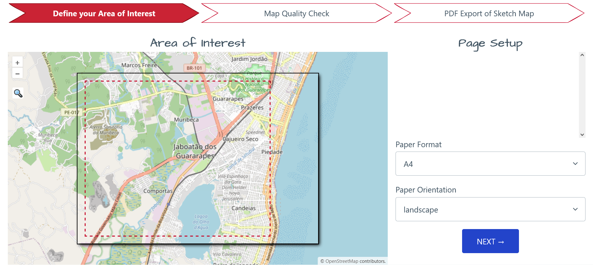
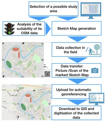
The Sketch Map Tool supports participatory mapping approaches and risk communication. An new paper presents the different functionalities of the tool. OSM data quality can be evaluated regarding the fitness for the sketch-map-approach. Based on the great idea of Field … Read More
GIScience at GeOnG 2020
These days so much is different- also conferences. Carolin Klonner and Marcel Reinmuth attended the GeOnG 2020 virtually. Thanks to the organizers! It worked well and there was great exchange between the participants. The workshop on experiences in defining health … Read More
Humanitarian OpenStreetMap Team has been selected by the Audacious Project
The Humanitarian OpenStreetMap Team (HOT) has announced major financial support from the Audacious Project, which will be provided over the next five years. HOT aims to use this funding to grow OpenStreetMap (OSM) communities in 94 countries. By engaging one … Read More
ISCRAM 2019 in Valencia- Towards closer exchange in crisis management between practitioners, stakeholders and researchers
The 16th ISCRAM conference took place in the city of Valencia (Spain). It succeeded again to gather an international audience of researchers that shared their work all around crisis management. As ISCRAM is mainly interested in the support and intersection … Read More
HeiGIT/ GIScience at ISCRAM conference in Valencia
19th-22nd of May, the 16th Information Systems for Crisis Response and Management (ISCRAM) conference is taking place in Valencia. Likewise to previous years, the GIScience Research Group/HeiGIT are taking part and supporting with several contributions. Martin Hilljegerdes will present a … Read More

