In 2020, the Humanitarian OpenStreetmap Team (HOT) was selected for The Audacious Project, a collaborative philanthropic initiative that serves as a springboard for social impact on a grand scale. This allows HOT to expand its activities and scale up support … Read More
English
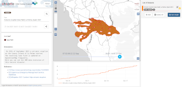
2021 Volcanic Eruption in La Palma (Spain) continues – Explore the temporal changes of the Lava Field in OpenStreetMap on ohsomeHeX
On the 19th of September 2021 a volcanic eruption on the Canary Island of La Palma started. Since then the resulting lava field is constantly growing and continues its destructive expansion. According to an article in the spanish newspaper El … Read More
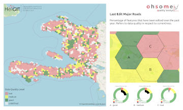
HeiGIT and MapAction at FOSS4G 2021: Using the ohsome quality analyst to support humanitarian mapping
Last week, the annual conference FOSS4G (Free and Open Source Software for Geospatial) has been taken place online. The conference is organized by The Open Source Geospatial Foundation (OSGeo) and attracts over 1000 developers, users, decision-makers and observers from a … Read More
ohsome Region of the Month – August
Hello and welcome back to the ohsome Region of the Month-blog post series where you can read about potential use cases of the ohsome API and maybe even get inspired to send some requests of your own. If you are … Read More
Analysing the Impact of Large Data Imports in OpenStreetMap
OpenStreetMap (OSM) is a global mapping project which generates free geographical information through a community of volunteers. OSM is used in a variety of applications and for research purposes. However, it is also possible to import external data sets to … Read More
HeiGIT/GIScience @ State of the Map 2021
Like in 2020, this year’s State of the Map (SotM) is taking place online this week from tomorrow 2021-07-09 to 2021-07-11, starting at 12:00 (CEST) each day. This year, HeiGIT is a bronze sponsor. In addition, there are a total … Read More
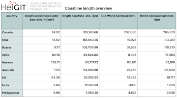
ohsome region of the month: Which country has the longest coastline?
The ohsome region of the month blog post series is back and since it’s summer this time we’re taking you to the coast. Before that happens, if this is your first blog post of this format you might want to … Read More
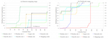
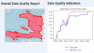
OSM data quality analysis for different stages of the mapping process
Slums are an important operational area for humanitarian organisations: Because of provisional housing, poor sanitation and difficult socio-political circumstances offers of help from such organisations are important and often necessary. For such deployments, humanitarian actors rely heavily on Volunteered Geographic … Read More
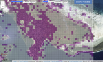
Monitoring OSM and Tasking Manager to Map 1 Billion
In 2020, the Humanitarian OpenStreetMap Team (HOT) received funding from seven donors through TED’s Audacious Project. This has accelerated HOT’s ambition to map an area home to one billion people. HOT is working to add places at high risk of … Read More

GIScience and HeiGIT contributions to AGILE 2021 conference
The AGILE 2021 conference is taking place this week. It is the the 24rd AGILE conference on GIScience. AGILE is the Association of Geographic Information Laboratories in Europe and the 2021 conference is for the first time held as a … Read More
Automatic building detection with ohsome2label and Tensorflow
Accurate and complete geographic data of human settlement is crucial for humanitarian aid and disaster response. OpenStreetMap (OSM) can serve as a valuable source, especially for global south countries where buildings are largely unmapped. In a previous blog, we introduced … Read More
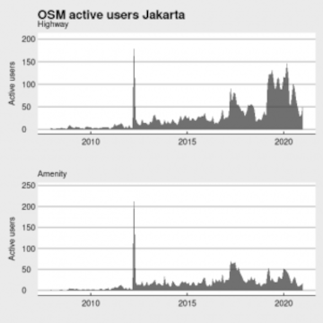
Becoming ohsome in R – analysis of the completeness of the road network and health sites in Jakarta
Data quality is an important issue then performing analysis based on OpenStreetMap data. We have recently demonstrated how the effects of the 2013 flood in Jakarta on the accessibility of hospitals and clinics could be analyzed based on network analysis … Read More
The ohsome quality analyst goes public on Github with new release 0.3.0
The ohsome quality analyst (short: OQT) has been introduced at the beginning of this year and today we are proud to announce two updates. First, we released the new version 0.3.0 which includes new OSM layers and a brand new … Read More
ohsomeHeX provides access to OSM feature history
Did you ever wonder how your city was mapped over time, how geometries were changed and refined, how mistakes were added and corrected again? Then read on: ohsomeHex has a great new feature for you – the individual object’s zoom-in-history-view. … Read More
Ohsome Region of the Month Building-Information Analysis
Welcome back to our blog post series ”ohsome Region of the Month” where you can find information on potential applications of the ohsome API. If you’re new to this format you can also read some of the former blog posts … Read More
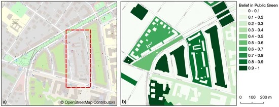
Mapping Public Urban Green Spaces Based on OpenStreetMap and Sentinel-2 Imagery Using Belief Functions
Public urban green spaces are important for the urban quality of life. Still, comprehensive open data sets on urban green spaces are not available for most cities. As open and globally available data sets, the potential of Sentinel-2 satellite imagery … Read More
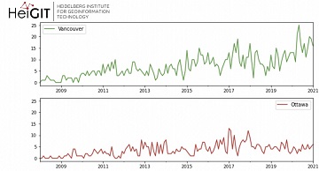
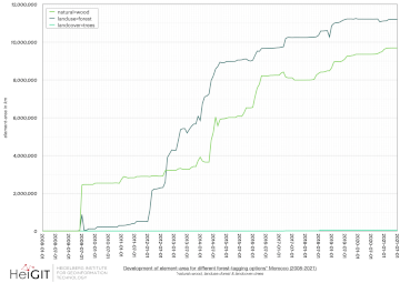
Ohsome Green Region of the Month
Welcome back to the ohsome region of the month format where you can learn and get inspiration about potential applications of the ohsome API. This time we looked at forest-related information in four different Canadian regions looking for the green … Read More
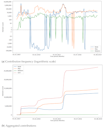
Towards a framework for the analysis of local OSM contributions
Volunteered Geographic Information (VGI) such as OpenStreetMap (OSM) is often defined as the collaborative acquisition of geographic information and local knowledge by volunteers, amateurs or professionals (Goodchild, 2007). The increasing availability and importance of local data in OSM is largely … Read More
ohsome-py: Python Package for OSM history analytics published
As a little Easter present, we published the first version of the ohsome-py Python package today. ohsome-py helps you extract and analyse OpenStreetMap history data using the ohsome API and Python. It handles queries to the ohsome API and converts … Read More
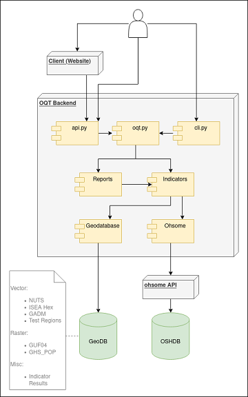
Behind the scenes of the ohsome quality analyst (OQT)
The #ohsome quality analyst (short: OQT) has been online and accessible through its web-interface now for quite some weeks already (see the introductory blog post as a reference). The website is not the only access point to the OQT though. … Read More