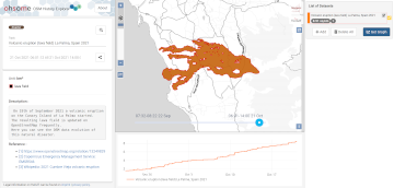
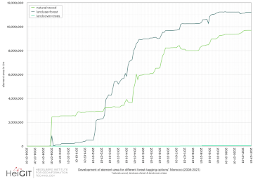
On the 19th of September 2021 a volcanic eruption on the Canary Island of La Palma started. Since then the resulting lava field is constantly growing and continues its destructive expansion. According to an article in the spanish newspaper El … Read More
English
Automatic mapping of national surface water with OpenStreetMap and Sentinel-2 MSI data using deep learning
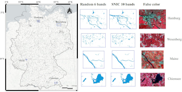
Large-scale mapping activities can benefit from the vastly increasing availability of earth observation (EO) data, especially when combined with volunteered geographical information (VGI) using machine learning (ML). High-resolution maps of inland surface water bodies are important for water supply and … Read More
HeiGIT and MapAction at FOSS4G 2021: Using the ohsome quality analyst to support humanitarian mapping
Last week, the annual conference FOSS4G (Free and Open Source Software for Geospatial) has been taken place online. The conference is organized by The Open Source Geospatial Foundation (OSGeo) and attracts over 1000 developers, users, decision-makers and observers from a … Read More
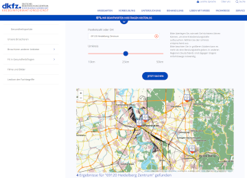
HeiGIT Maps support DKFZ’s Cancer Information Service
One of HeiGIT’s goals is the beneficial use of geoinformation for society. To this end we provide a range of different Web services, mostly based on OpenStreetMap (OSM), such as openrouteservice or the OSM history analytics platform ohsome.org. In particular … Read More
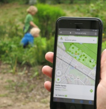
A Web App to generate and disseminate knowledge on urban green space qualities and their accessibility
Urban green spaces (UGSs) can provide important ecosystem services for citizens and their well-being. To make use of these services according to UGS user demands, urban residents, tourists, and city administrations should know where UGSs are located, what qualities they … Read More
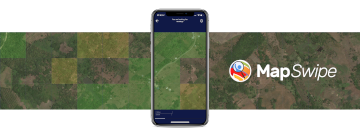
MapSwipe is App of the Day in Apple AppStore
MapSwipe has ben announced as ‘App of the Day‘ in the Apple AppStore! (27.08.2021) Thank you to all our volunteers for the continued help and support which keeps the app going. Read the blogpost here: https://apps.apple.com/ca/story/id1559236909 The team at the … Read More
ohsome Region of the Month – August
Hello and welcome back to the ohsome Region of the Month-blog post series where you can read about potential use cases of the ohsome API and maybe even get inspired to send some requests of your own. If you are … Read More
Revamped openrouteservice client for disaster management
We are happy to announce a revamped openrouteservice maps client for disaster management. It was built based on the new openrouteservice maps client, that is an open source route planner with plenty of features. Specific disaster features were incorporated via … Read More
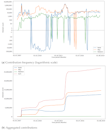
Analysing the Impact of Large Data Imports in OpenStreetMap
OpenStreetMap (OSM) is a global mapping project which generates free geographical information through a community of volunteers. OSM is used in a variety of applications and for research purposes. However, it is also possible to import external data sets to … Read More
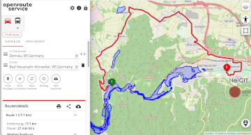
Routing in flooded areas: openrouteservice uses Copernicus EMS flooding data for specific solution
The current flooding in Germany has destroyed countless streets or temporarily made them impassable in the affected areas. HeiGIT is working on free and open solutions for humanitarian aid that are based on geodata. This particularly includes routing that incorporates … Read More
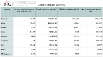
ohsome region of the month: Which country has the longest coastline?
The ohsome region of the month blog post series is back and since it’s summer this time we’re taking you to the coast. Before that happens, if this is your first blog post of this format you might want to … Read More
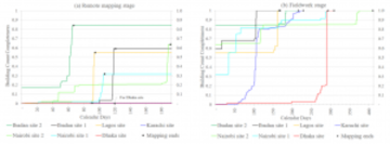
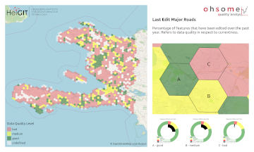
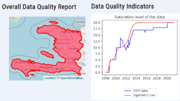
OSM data quality analysis for different stages of the mapping process
Slums are an important operational area for humanitarian organisations: Because of provisional housing, poor sanitation and difficult socio-political circumstances offers of help from such organisations are important and often necessary. For such deployments, humanitarian actors rely heavily on Volunteered Geographic … Read More
Ein Jahr WebApp „meinGrün“ – finale Befragung und Ergebnispräsentation
Im Juni 2020 haben wir mit unseren Partnern aus dem meinGrün Projekt die gleichnamige WebApp gestartet. Nun sind die Nutzenden in Dresden und Heidelberg aufgerufen, sich ein letztes Mal an einer Befragung zu beteiligen und so Hinweise für die mögliche … Read More
Openrouteservice for complex route optimization in new QGIS extension by Regionalverband Ruhr
The Regionalverband Ruhr (Team 9-2 Geodata Technology) has used the potential of HeiGIT’s openrouteservice (ORS) in a new QGIS extension and thereby created another possible application for the ORS: The tool “Location and Route Optimization of Addresses” allows to search … Read More
The ohsome quality analyst goes public on Github with new release 0.3.0
The ohsome quality analyst (short: OQT) has been introduced at the beginning of this year and today we are proud to announce two updates. First, we released the new version 0.3.0 which includes new OSM layers and a brand new … Read More
All countries of Central and South America now on Open Healthcare Access Map
After Sub-Saharan Africa and South and Southeast Asia we have now published all countries of Central and South America on the Open Healthcare Access Map. The web application is available here: https://apps.heigit.org/healthcare_access/. Please note that this is still a prototype … Read More
Third International Mapathon on Mon 17.05.2021 by disastermappers heidelberg, MAMAPA, CartONG, HuMap and OSM Ghana
Dear mappers, on Monday 17.5.2021, 18.00pm a third international mapathon together with disastermappers heidelberg, MAMAPA, CartONG, HuMap and OSM Ghana will take place, which will give you some insights in mapping for humanitarian purposes from the perspective of different organizations … Read More
Ohsome Region of the Month Building-Information Analysis
Welcome back to our blog post series ”ohsome Region of the Month” where you can find information on potential applications of the ohsome API. If you’re new to this format you can also read some of the former blog posts … Read More
Reminder – starting THIS week: Evaluating Two-part OSM Mapathons on Mai 05 and May 11
The project “25 Mapathons“ goes into the next phase. Based on the experience of until today 17 OSM mapathons with German Red Cross (GRC) chapter and an extensive literature review on the success of mapathons, the “25 Mapathons” team has … Read More
Die Stadt Mannheim nutzt openrouteservice für die Routenplanung in ihrem Online-Stadtplan
Seit kurzem nutzt die Stadt Mannheim openrouteservice (ORS) von HeiGIT für das Routing von Fußgängern, Fahrräder, Autos, LKW und Rollstuhlfahrern im Online-Stadtplan für die breite Öffentlichkeit, d.h. die Bürger und Besucher von Mannheim. Sie können es hier verwenden: https://www.gis-mannheim.de/mannheim/index.php?bl=wms_web_grau&service=mannheim<=mod_ors Dies … Read More