Introduction Since the release of the ohsome quality analyst (short OQT) in February of last year, we have been working on developing an accessible yet powerful toolkit which provides end users insights on the quality of OpenStreetMap (OSM) data. An … Read More
English
How to become ohsome part 14 – Advanced dashboarding
Hello again and welcome back to our “How to become ohsome” series where we demonstrate how you too can become ohsome with ohsome API! If you’re new to the series or need a refresher, check out the older installments in … Read More
How to become ohsome part 13 – An ohsome way to check if OSM is up to date
At long last, welcome to another addition of our How to become ohsome-series! This one is special because we’re discussing a third-party application that uses ohsome API as back-end to accumulate historical OSM data. Although this innovation isn’t directly about our API, … Read More
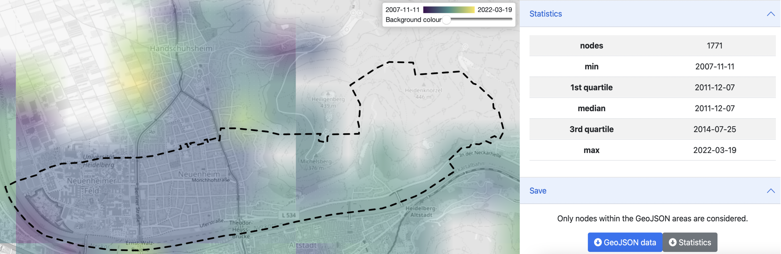
ohsome Region of the Month: hiking-related tags & mountains
Welcome back to a new installment of the ohsome Region of the Month blog series! This will be part two our posts on hiking related tags and this time, we’ll investigate the connection between user activity and said tags. To … Read More
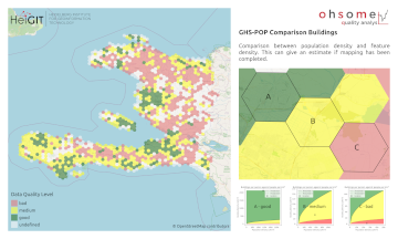
Recent feature additions to Ohsome Quality analysT
Since the release of the ohsome quality analyst (short OQT) in February of last year, we have been working on developing an accessible yet powerful toolkit which provides end users insights on the quality of OpenStreetMap (OSM) data. An overview … Read More
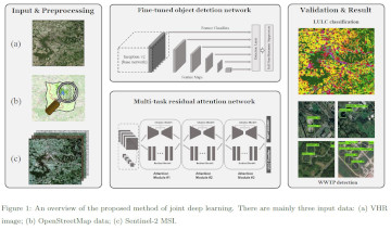
Leveraging OpenStreetMap and Multimodal Remote Sensing Data with Joint Deep Learning for Wastewater Treatment Plants Detection
Humans rely on clean water for their health, well-being, and various socio-economic activities. During the past few years, the COVID-19 pandemic has been a constant reminder of about the importance of hygiene and sanitation for public health. The most common … Read More
Spatial Data for Society – Leading HeiGIT to the Future
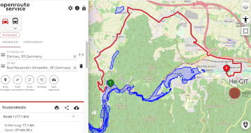
Underpasses, stairs, and high curbsides are a challenge for people with impaired mobility, but these can be circumnavigated using a customized route planner for increasing mobility by calculating routes with the least amount of obstacles. This example emphasizes how geoinformation technology and … Read More
ohsome Region of the Month – Mapping of pandemic related facilities
At long last, welcome back to out Region of the Month-series, where we look at different regions in the world and how tags are used there. Today we would like to look at Covid-19 related OpenStreetMap tags in Germany, Austria and Switzerland. … Read More
How to become ohsome part 12 – Using length and area as a predefined filter
Hello and welcome back to part 12 of our “How to become ohsome“-blog post series! If you’re new to this series, check out other blog posts of the series as well, in order to learn how you too, can become … Read More
ohsome quality analyst (OQT) auf der FOSSGIS Konferenz am 09.03.22
Vom 9. bis zum 12. März 2022 findet die jährliche FOSSGIS Konferenz statt, die führende Konferenz für Freie und Open Source Software für Geoinformationssysteme und Open Data im deutschsprachigen Raum. HeiGIT wird dabei am 09.03. um 16:30–16:50 Bühne 2 ONLINE … Read More
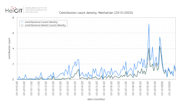
How to become ohsome part 11 – counting contributions
Hello and welcome back to the How to become ohsome-blog series! We hope the new year started off well for you! If you’re new to the series, you should read our other posts in the series, as well as the … Read More
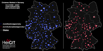
How to become ohsome part 10 – ohsome holiday contributions
Welcome back to our blog post series How to become ohsome, where you get short and simple explanations on how you can become ohsome yourself! This time, it’s all about our new endpoints, which enable you to track which contributions … Read More
United Nations World Data Forum Blog on Healthcare Accessibility Map
In the context of the United Nations World Data Forum 2021 organised by the United Nations Statistics Division and UN member states a series of blogposts has been published by UNSTATS. Among them is one by Alexander Zipf about improving … Read More
HGG Vortrag: Digitale Geographie im Katastrophenmanagement
Einladung Vortrag Online: Dienstag, 14. Dezember 2021, 19:15 Uhr Melanie Eckle-Elze, Benjamin Herfort, Dr. Carolin Klonner Digitale Geographie im Katastrophenmanagement Klimawandel, Bevölkerungswachstum, Verstädterung und weitere zunehmende Landnutzungsveränderungen führen dazu, dass immer mehr Menschen in Risikogebieten leben. Um die vorhandenen Risiken … Read More
HeiGIT and GIScience at Virtual Conference of the Red Cross Red Crescent Urban Collaboration Platform 2021
On Friday, November 26th, Dr. Carolin Klonner (GIScience Research Group) and Melanie Eckle-Elze (HeiGIT) will be supporting the Urban Context Unit of German Red Cross (GRC) in the “Data and Digitalisation in Urban Humanitarian Action” session at the Virtual Conference … Read More
How to become ohsome part 9 – More ways to access the ohsome API
At long last, welcome back to a new blog post of the “How to become ohsome“-series. As it’s been quite a while since you got an introduction to how to access the ohsome API, we would like to pick up … Read More
FOSS4G 2021 Videos with HeiGIT contributions online – OSM data quality and MapSwipe
Recently videos with our contributions by HeiGIT to the FOSS4G conference were put online. Did you miss the event? Now you can watch whenever you like 🙂 Benni by HeiGIT explains who to use the ohsome.org framework to develop an … Read More
ohsome Region of the Month – crop tagging
Hello and welcome back to another blog post of the ohsome Region of the Month series where you can learn about potential use cases of the ohsome API. This month we were be looking at the crop tag and tried … Read More
meinGrün, Tradur und SocialMedia2Traffic bei der mFUND Konferenz 2021
Letzte Woche konnten wir bei der digitalen mFUND Konferenz drei unserer Projekte einem interessierten Publikum vorstellen. Im Fachforum “Die „15-Minuten-Stadt“ datenbasiert ermöglichen” haben wir gezeigt, wie die meinGrün App, das meinGrün Webportal und die angegliederten Dienste Städte dabei unterstützen könnten, … Read More
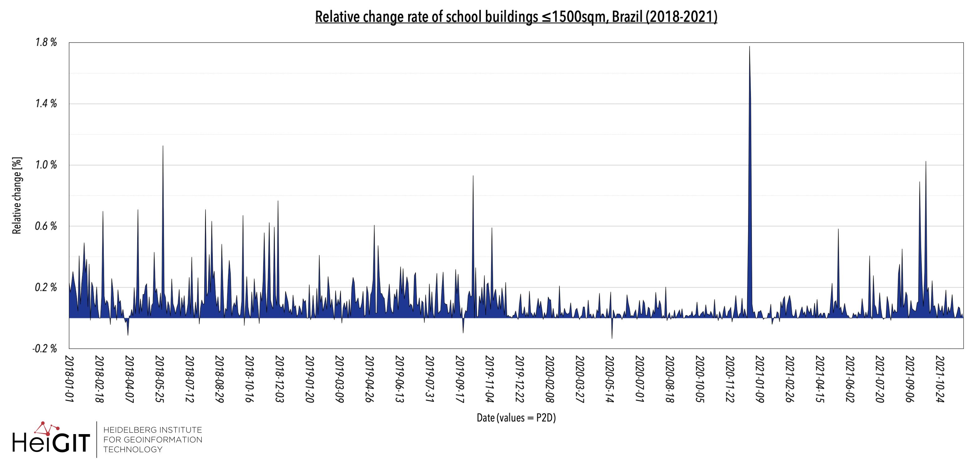
HOT-MERL Monitoring OSM and Tasking Manager
In 2020, the Humanitarian OpenStreetmap Team (HOT) was selected for The Audacious Project, a collaborative philanthropic initiative that serves as a springboard for social impact on a grand scale. This allows HOT to expand its activities and scale up support … Read More