Already in October 2019 Prof. Zipf was invited to give a keynote on “User Generated Geoinformation for Smart Cities” at the “Smart Cities, Smart Data, Smart Governance” ISPRS Conference at…
We are pleased to announce the latest release of openrouteservice – version 6.0 also known as Ganymede. The main changes in this release are nestled in the backend code itself…
Last week was the Smart City Expo World Congress 2019 took place in Barcelona. Our region geoinformation network GeoNet.MRN was there with a booth presenting the members of GeoNet.MRN, among…
Over the last few days, Heidelberg’s first climathon event took place at EMBL, which was part of the global Climathon. The event ran from 25th-27th October 2019 with a 24…
We’re happy to announce a new version of our QGIS Plugin ORS Tools. Additionally to the core services of giving easy access to our directions, isochrone and matrix API’s, the…
We are delighted to invite you to join a workshop on open-source routing with time-dependent restrictions, see http://giscienceblog.uni-hd.de/2019/04/17/project-tardur-starts-open-source-routing-with-time-dependent-restrictions/. The workshop is taking place on Friday before the State of the…
Routing optimization in a humanitarian context Routing optimization generally solves the Vehicle Routing Problem (a simple example being the more widely known Traveling Salesman Problem). A more complex example…
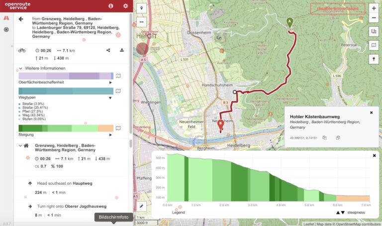
IT IS HOT! So you are looking for a more shady pedestrian route through the urban jungle? You might then prefer some routes that go through public green spaces with…
As promised earlier this year, we’re very happy to finally announce the unveiling of our new route optimization endpoint! We deployed an instance of the popular Vroom open-source engine, which…
Alle Jahre wieder blühen die Kirschbäume vor unserem Institutsgebäude in voller Pracht und laden Passanten allen Alters ein zum Verweilen. Städtische Grünflächen wie diese leisten einen wichtigen Beitrag zur urbanen…
Time-dependent restrictions and temporal road closures are so far not considered in any freely available software for route planning. Heidelberg University and the company GraphHopper aim to address this issue…
A first preview on the new client for Openrouteservice has been released as a public beta. It is available at https://openrouteservice.org/map/ . Wit the features implemented until now the new…
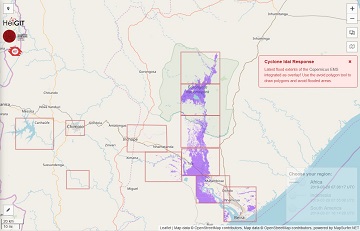
The Humanitarian OpenStreetMap Team (HOT) has launched an activation to support humanitarian operations responding to the impact of Cyclone Idai. These efforts were already supported by more than 1500 mappers…
openrouteservice Io is here! The openrouteservice from HeiGIT has just had its latest update, and we want to introduce you to Io (version 5.0). This new version brings something that…
In addition to our already exciting and fascinating portfolio of open source software we now offer openfuelservice which is a new and very experimental advance in the world of fuel…
Finally there is a new version of the QGIS plugin for OpenRouteService: ORS Tools. It gives easy access to our directions, isochrone and matrix API’s from within QGIS. The old…
You can also use Openrouteservice via the self-service data analytics plattform alteryx, when you are a user of that data science product. Pablo Sáenz de Tejada (The Information Lab) has…
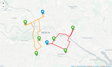
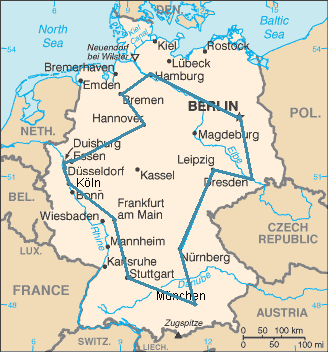
The most optimal route through Germany’s 15 biggest citys. It’s the shortest route of exactly 43.589.145.600 different alterations. In a Vehicle Routing Problem (VRP, an example is the Traveling Salesman…
The new year started in the openrouteservice team at HeiGIT with the release of openrouteservice 4.7.2. In this release there were a number of bug fixes, but also some new…
In addition to our previously released and highly appreciated python and R libraries we now offer an additional JavaScript API making the usage of the openrouteservice ecosystem covering the entire…