MapSwipe has ben announced as ‘App of the Day‘ in the Apple AppStore! (27.08.2021) Thank you to all our volunteers for the continued help and support which keeps the app going. Read the blogpost here: https://apps.apple.com/ca/story/id1559236909 The team at the … Read More
Blog
ohsome Region of the Month – August
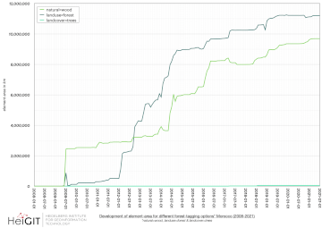
Hello and welcome back to the ohsome Region of the Month-blog post series where you can read about potential use cases of the ohsome API and maybe even get inspired to send some requests of your own. If you are … Read More
Revamped openrouteservice client for disaster management
We are happy to announce a revamped openrouteservice maps client for disaster management. It was built based on the new openrouteservice maps client, that is an open source route planner with plenty of features. Specific disaster features were incorporated via … Read More
Analysing the Impact of Large Data Imports in OpenStreetMap
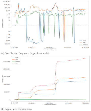
OpenStreetMap (OSM) is a global mapping project which generates free geographical information through a community of volunteers. OSM is used in a variety of applications and for research purposes. However, it is also possible to import external data sets to … Read More
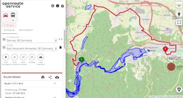
Routing in flooded areas: openrouteservice uses Copernicus EMS flooding data for specific solution
The current flooding in Germany has destroyed countless streets or temporarily made them impassable in the affected areas. HeiGIT is working on free and open solutions for humanitarian aid that are based on geodata. This particularly includes routing that incorporates … Read More
SWR broadcast on the research project HEAL: Taking the safe route through the heat – Transdisciplinary project HEAL makes everyday life easier for at-risk groups
Climate adaptation strategies to support and protect at-risk groups during hot weather periods are being developed as part of the transdisciplinary collaboration in the HEAL project by the research network consisting of the Heidelberg Institute for Geoinformation Technology (HeiGIT), the … Read More
HeiGIT/GIScience @ State of the Map 2021
Like in 2020, this year’s State of the Map (SotM) is taking place online this week from tomorrow 2021-07-09 to 2021-07-11, starting at 12:00 (CEST) each day. This year, HeiGIT is a bronze sponsor. In addition, there are a total … Read More
GIScience/HeiGIT researchers and geography students with Pledge4Future web app official winners of the “The Climate Challenge Hackathon”
Pledge4Future is a free web app for the calculation and visualisation of work-related per capita CO2e emissions in research. The aim is to provide individuals and work groups with a simple tool for the long-term reduction of greenhouse gas emissions … Read More
A safe way through the heat: Transdisciplinary project HEAL makes everyday life easier for at-risk groups
As part of a transdisciplinary collaboration, the Heidelberg Institute for Geoinformation Technology (HeiGIT), the GIScience research group and the TdLab Geography at Heidelberg University are jointly developing adaptation strategies to support and protect at-risk groups during hot weather conditions. Individual … Read More
New paper on OSM feature completeness modelling accepted for AGIT symposium
The availability of data on public transport is a prerequisite for numerous spatial data applications such as routing, accessibility analyses or route planning. OpenStreetMap (OSM) – as a global platform for Volunteered Geographic Information – is one of the options … Read More
OSM Changeset Analysis with Humstats and the ohsome Framework
In this blog post we want to take a closer look at a fruitful mapping collaboration between humanitarian organizations and corporations. Since 2015 mapping remote areas in OSM is one part in the cooperation between the leading savings, retirement and … Read More
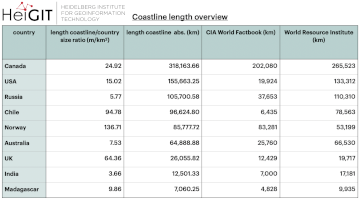
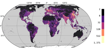
ohsome region of the month: Which country has the longest coastline?
The ohsome region of the month blog post series is back and since it’s summer this time we’re taking you to the coast. Before that happens, if this is your first blog post of this format you might want to … Read More
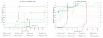
OSM data quality analysis for different stages of the mapping process
Slums are an important operational area for humanitarian organisations: Because of provisional housing, poor sanitation and difficult socio-political circumstances offers of help from such organisations are important and often necessary. For such deployments, humanitarian actors rely heavily on Volunteered Geographic … Read More
Monitoring OSM and Tasking Manager to Map 1 Billion
In 2020, the Humanitarian OpenStreetMap Team (HOT) received funding from seven donors through TED’s Audacious Project. This has accelerated HOT’s ambition to map an area home to one billion people. HOT is working to add places at high risk of … Read More
Ein Jahr WebApp „meinGrün“ – finale Befragung und Ergebnispräsentation
Im Juni 2020 haben wir mit unseren Partnern aus dem meinGrün Projekt die gleichnamige WebApp gestartet. Nun sind die Nutzenden in Dresden und Heidelberg aufgerufen, sich ein letztes Mal an einer Befragung zu beteiligen und so Hinweise für die mögliche … Read More
World Refugee Day: Mapathon by CartONG
Whether you are a beginner or an advanced mapper, or just curious to learn more about why mapping is so important for humanitarian work, join us on 21 June. Support the mapping of refugee locations on World Refugee Day. It … Read More
Openrouteservice for complex route optimization in new QGIS extension by Regionalverband Ruhr
The Regionalverband Ruhr (Team 9-2 Geodata Technology) has used the potential of HeiGIT’s openrouteservice (ORS) in a new QGIS extension and thereby created another possible application for the ORS: The tool “Location and Route Optimization of Addresses” allows to search … Read More
HeiGIT und das Deutsche Rote Kreuz beim Digitaltag 2021
Am 18.06.2021 findet der Bundesweite Digitaltag 2021 der Initiative „Digital für alle“ statt. Der Digitaltag ist eine Plattform, auf der digitale Projekte und Aktionen aus der Zivilgesellschaft vorgestellt werden und das Thema Digitalisierung von verschiedenen Seiten beleuchtet wird. Mit dem … Read More

AGILE best short paper award nominees
We are happy to announce that two of our papers have been shortlisted as candidates for the best short paper award at the AGILE 2021 conference : Detecting OpenStreetMap missing buildings by transferring pre-trained deep neural networks Jan Pisl, Hao … Read More
GIScience and HeiGIT contributions to AGILE 2021 conference
The AGILE 2021 conference is taking place this week. It is the the 24rd AGILE conference on GIScience. AGILE is the Association of Geographic Information Laboratories in Europe and the 2021 conference is for the first time held as a … Read More