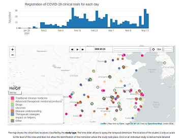
Many informative maps are available to follow the spread of COVID-19. This is important information but only part of the story. The global scientific and medical communities have immediately responded to the outbreak with focused research activities. This has led … Read More
Blog
25 Jahre Klaus Tschira Stiftung: KTS fördert zum Jubiläum zahlreiche 25er Aktionen – HeiGIT mit 25 Mapathons dabei
25 Jahre Klaus Tschira Stiftung: KTS fördert zum Jubiläum zahlreiche 25er Aktionen – HeiGIT mit 25 Mapathons dabei In diesem Jahr wird die Klaus Tschira Stiftung (KTS) 25 Jahre alt. Zu ihrem Jubiläum hat sich die Stiftung eine ganze Reihe … Read More
Deadline extension: IJGI Special Issue on “OpenStreetMap as a Multi-Disciplinary Nexus: Perspectives, Practices, and Procedures”
As noted in a previous blogpost, the scientific committee of the Academic Track of State of the Map 2019 – Dr. Yair Grinberger, until recently a member of the GIScience research group, Dr. Marco Minghini, Dr. Levente Juhász, Dr. Peter … Read More
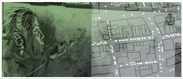
ISPRS IJGI highlights our work on deep learning of Street Art from VGI and Street View Images
We are pleased to share that because of the response to our work, ISPRS IJGI selected our paper on Detecting Graffiti with Street View Images and Deep Learning to be highlighted as a title story through some graphics on the … Read More
MapSwipe wins Global Mobile Award for the Best Mobile Innovation Supporting Emergency or Humanitarian Situations
This week, at the prestigious GSMA MWC series (formally known as Mobile World Congress) MapSwipe was awarded the top prize in the Global Mobile Awards’ category for the Best Mobile Innovation Supporting Emergency or Humanitarian Situations. The award recognizes how … Read More
Volunteered Geographic Information research in the first decade: a narrative review of selected journal articles in GIScience
More than 10 years have passed since the coining of the term volunteered geographic information (VGI) in 2007. A recently published article presents the results of a review of the literature concerning VGI. A total of 346 articles published in … Read More
Colloquium Talk about healthsites.io: Building a baseline of health facility data in OpenStreetMap by M. Herringer
We are happy to invited to the presentation in the GIScience HD colloquium. Everybody interested is invited to join the presentations and the discussion afterwards. Building a baseline of health facility data in OpenStreetMap Markus Herringer, healthsites.io, Amsterdam, NL – … Read More
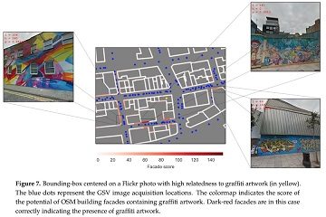
Detecting OSM Building Facades with Graffiti Artwork Based on Street View Images and Social Media using Deep Learning
As a recognized type of art, graffiti is a cultural asset and an important aspect of a city’s aesthetics. As such, graffiti is associated with social and commercial vibrancy and is known to attract tourists. However, positional uncertainty and incompleteness … Read More

GIScience Contributions to the 2019 State of the Map Academic Track proceedings
Recently the SOTM 2019 Heidelberg Academic Track Proceedings have been published. GIScience Research Group Heidelberg and HeiGIT contributed several talks and posters. Below you can find an overview. Contact us if you are interested in further details on ongoing research. … Read More
Learning salience models of indoor landmarks
In landmark-based way-finding, determining the most salient landmark from several candidates at decision points is challenging. To overcome this problem, current approaches usually rely on a linear model to measure the salience of landmarks. However, linear models are not always … Read More
ohsome presentation in Malta at the 3rd International Workshop on Spatial Data Quality
Around 55 participants gathered in Malta for the 3rd International Workshop on Spatial Data Quality 2020 from 28th to 29th of January. Among national mapping agencies, software providers and standardization organizations, HeiGIT had the opportunity to present its ohsome – … Read More
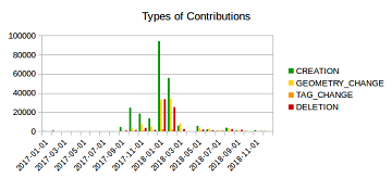
Mapping Rohingya Refugee Camps in Bangladesh – An Analysis Using the OSHDB API
Humanitarian mapping activations show increasing numbers of contribution. This blog post illustrates the specific potential of the OSHDB API [1] for detailed analyses of such activations by means of a case study. The examined area is Cox’s Bazar in Southeast … Read More
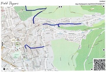
Urban flooding in Handschuhsheim – Using User-Generated Geographic Data in Flood Risk Management
A week ago, students from the seminar “User-Generated Geographic Data in Disaster Risk Management and Humanitarian Aid” carried out a survey about urban flood risk in Handschuhsheim. The “field day” was organised by Carolin Klonner and Melanie Eckle (the teachers … Read More
Invitation to GIScience colloquium talks related to Humanitarian Aid
We are happy to annouce two higly interesting upcomming presentations in the GIScience colloquium in the next weeks. Everybody interested is invited to join the presentations and the discussion afterwards. The use of geoinformatics at the German Red Cross Katharina … Read More
Disaster monitoring with Openrouteservice, example from UN Pulse Lab Jarkarta
Recently the UN Pulse Lab Jakarta has developed a disaster monitoring WebApp called the MIND/DisasterMon platform. According to UN Pulse Lab the objective of the MIND/DisasterMon platform is to try to answer questions related to Disaster Monitoring and emergency response … Read More
NASA uses Openrouteservice for study on disaster response times
According to a recent post by NASA, researchers at NASA’s Goddard Space Flight Center in Greenbelt, Maryland, calculated the time that could have been saved if ambulance drivers and other emergency responders had near-real-time information about flooded roads, using the … Read More
Recap: Keynote on Smart Cities
Already in October 2019 Prof. Zipf was invited to give a keynote on “User Generated Geoinformation for Smart Cities” at the “Smart Cities, Smart Data, Smart Governance” ISPRS Conference at CEPT University in Ahmedabad (known for the Gandhi-Ashram), where he … Read More
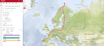
Openrouteservice v6.0 – Ganymede
We are pleased to announce the latest release of openrouteservice – version 6.0 also known as Ganymede. The main changes in this release are nestled in the backend code itself and have been performed to update the core GraphHopper library … Read More
Final call and extended deadline: CfP for a special issue of Transactions in GIS
The deadline for the Call for Papers for a special issue of Transactions of GIS on “The Geographical and Cultural Aspects of Geo-Information” had been extended to the 31 January 2020. The special issue, organized by the GIScience colleagues Dr. … Read More
Seasons Greetings from GIScience Heidelberg & HeiGIT, have a great New Year 2020
Dear friends and colleagues, we wish you a relaxing and peaceful holiday season and all the very best for a happy and prosperous New Year. The most important event of this turbulent year was for us the founding of HeiGIT … Read More

