Einladung Vortrag Online: Dienstag, 14. Dezember 2021, 19:15 Uhr Melanie Eckle-Elze, Benjamin Herfort, Dr. Carolin Klonner Digitale Geographie im Katastrophenmanagement Klimawandel, Bevölkerungswachstum, Verstädterung und weitere zunehmende Landnutzungsveränderungen führen dazu, dass…
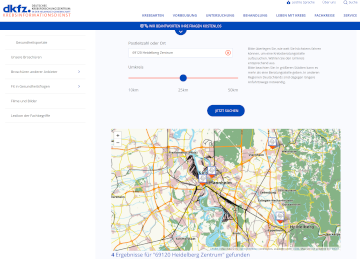
Aktuelle Meldung der Universität Heidelberg zum Projekt HEAL: https://www.uni-heidelberg.de/de/newsroom/wenn-es-in-der-stadt-zu-heiss-wird BADEN-WÜRTTEMBERG STIFTUNG FÖRDERT HEIDELBERGER PROJEKT ZU ROUTINGDIENST MIT HITZEVERMEIDENDEN WEGSTRECKEN Wo in der Stadt Heidelberg ist es besonders heiß und wie…
In 2020, the Humanitarian OpenStreetmap Team (HOT) was selected for The Audacious Project, a collaborative philanthropic initiative that serves as a springboard for social impact on a grand scale. This…
On October 12th the “25 Mapathon project” was finalized with an exceptionally successful public online mapathon. Around 20 participants with various professional backgrounds mapped 2273 buildings in three hours to…
One of HeiGIT’s goals is the beneficial use of geoinformation for society. To this end we provide a range of different Web services, mostly based on OpenStreetMap (OSM), such as…
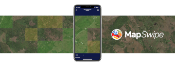
MapSwipe has ben announced as ‘App of the Day‘ in the Apple AppStore! (27.08.2021) Thank you to all our volunteers for the continued help and support which keeps the app…
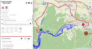
The current flooding in Germany has destroyed countless streets or temporarily made them impassable in the affected areas. HeiGIT is working on free and open solutions for humanitarian aid that…
Climate adaptation strategies to support and protect at-risk groups during hot weather periods are being developed as part of the transdisciplinary collaboration in the HEAL project by the research network…
As part of a transdisciplinary collaboration, the Heidelberg Institute for Geoinformation Technology (HeiGIT), the GIScience research group and the TdLab Geography at Heidelberg University are jointly developing adaptation strategies to…
In this blog post we want to take a closer look at a fruitful mapping collaboration between humanitarian organizations and corporations. Since 2015 mapping remote areas in OSM is one…
The AGILE 2021 conference is taking place this week. It is the the 24rd AGILE conference on GIScience. AGILE is the Association of Geographic Information Laboratories in Europe and the…
Dear mappers, on Monday 17.5.2021, 18.00pm a third international mapathon together with disastermappers heidelberg, MAMAPA, CartONG, HuMap and OSM Ghana will take place, which will give you some insights in…
The project “25 Mapathons“ goes into the next phase. Based on the experience of until today 17 OSM mapathons with German Red Cross (GRC) chapter and an extensive literature review…
The impact of climate change is particularly strong in higher latitudes. The Arctic is currently warming up at a much higher pace than the global average. This leads to thawing…
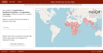
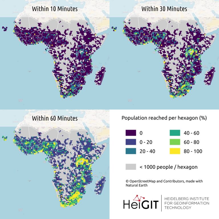
It’s been a little longer than a month since we published the Open Healthcare Access Map. Last week we rolled out all countries of Sub-Saharan Africa. Today all countries of…
A couple of viruses are of global interest with respect to human health and well-being. These pathogens include the novel coronavirus SARS-CoV-2, Dengue, Chikungunya, Yellow fever, Zika and Ebola. These…
The Heidelberg Institute for Geoinformation Technology (HeiGIT) and the international humanitarian geospatial charity MapAction have signed a Memorandum of Understanding (MoU) outlining their plans to collaborate in a number of…
Last month we started the Open Healthcare Access Map. Initially, only a few countries were featured. Gradually, more countries and regions are now being added. Today we release all countries…
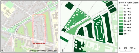
Public urban green spaces are important for the urban quality of life. Still, comprehensive open data sets on urban green spaces are not available for most cities. As open and…
The project “25 Mapathons“ goes into the next phase. Based on the experience of until today 17 OSM mapathons with German Red Cross (GRC) chapter and an extensive literature review…