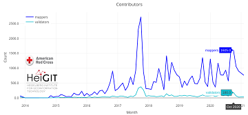
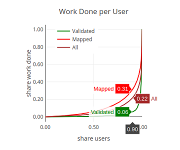
Since 2010 organized humanitarian mapping has evolved as a constant and growing element of the global OpenStreetMap (OSM) community. With more than 8,000 projects in 150 countries humanitarian mapping has become a global community effort. Due to this large amount … Read More
Deutsch

Projektstart von SocialMedia2Traffic – Ableitung von Verkehrsinformationen aus Social–Media-Daten
Aktuelle Verkehrsinformationen sind die Voraussetzung für Navigations-Lösungen, um die beste Route und Fahrzeit zu bestimmen. Es gibt jedoch keine frei verfügbaren Verkehrsinformationen auf weltweiter- und Bundesebene. „SocialMedia2Traffic nutzt frei verfügbare Daten aus sozialen Medien wie zum Beispiel Twitter-Nachrichten“, sagt Prof. … Read More
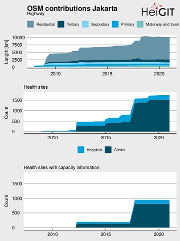
Flood Impact Assessment on Road Network and Healthcare Access at the example of Jakarta, Indonesia
Extreme natural events create catastrophic situations for cities and their populations. Due to climate change and anthropogenic activities, the number and intensity of these events has steadily increased at the global scale. Floods are the most common natural disaster worldwide, … Read More
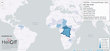
Humanitarian OSM Stats: How to monitor humanitarian mapping in the HOT Tasking Manager? – Part 4
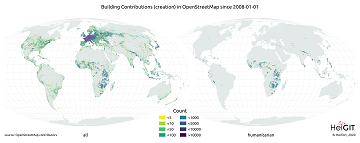
Since 2010, organized humanitarian mapping has evolved as a constant and growing element of the global OpenStreetMap (OSM) community. With more than 7,000 projects in 150 countries, humanitarian mapping has become a global community effort. Due to this large amount … Read More
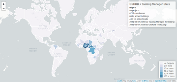
Humanitarian OSM Stats: How to monitor humanitarian mapping in the HOT Tasking Manager? – Part 3
Since 2010 organized humanitarian mapping has evolved as a constant and growing element of the global OpenStreetMap (OSM) community. With more than 7,000 projects in 150 countries humanitarian mapping has become a global community effort. Due to this large amount … Read More
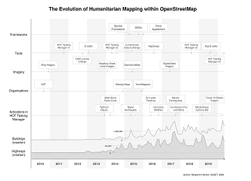
The evolution of humanitarian mapping within the OpenStreetMap community
In the past 10 years, the collaborative maps of OpenStreetMap (OSM) have been used to support humanitarian efforts around the world as well as to fill important data gaps for implementing major development frameworks such as the Sustainable Development Goals … Read More
Humanitarian OSM Stats: How to monitor humanitarian mapping in the HOT Tasking Manager? – Part 2
Since 2010 organized humanitarian mapping has evolved as a constant and growing element of the global OpenStreetMap (OSM) community. With more than 7,000 projects in 150 countries humanitarian mapping has become a global community effort. Due to this large amount … Read More
German radio report on OpenStreetMap in WDR5 Quarks – Wissenschaft und mehr
The German radio station WDR 5 broadcasted a short report about OpenStreetMap with a focus on basics and navigation in the science programme “Quarks – Wissenschaft und mehr” last month on 19.01.2021. One of the German pioneers of OpenStreetMap – … Read More
Vortrag zu Humanitärem Mapping in OpenStreetMap bei Begabtenförderung des Heidelberger Life‐Science Lab
Das Heidelberger Life‐Science Lab ist eine Einrichtung des Deutschen Krebsforschungszentrums (DKFZ, Heidelberg) und hat die Förderung mathematisch und naturwissenschaftlich-technisch besonders interessierter und begabter Mittel- und Oberstufenschüler und Studenten zur Aufgabe. Der Schwerpunkt ist auf die Life-Sciences gerichtet, die den Standort … Read More
ohsome street network analysis part 2
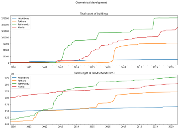
Welcome to part 2 of the #ohsome street network analysis. If you haven’t read the first part yet, you can do so following this link. As promised, this week we are performing a simple tag completeness analysis, where we are … Read More
Humanitarian OSM Stats: How to monitor humanitarian mapping in the HOT Tasking Manager? – Part 1
Since 2010 organized humanitarian mapping has evolved as a constant and growing element of the global OpenStreetMap (OSM) community. With more than 7,000 projects in 150 countries humanitarian mapping has become a global community effort. Due to this large amount … Read More
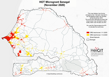
Updated OSM Healthcare in Senegal (2020)
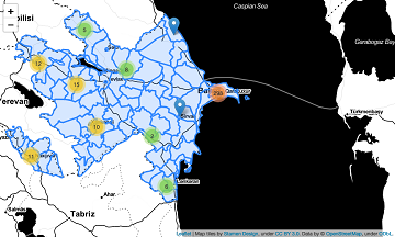
OpenStreetMap (OSM) offers many possibilities and holds potential in the area of freely available infrastructure data for the health sector. Nevertheless, it is important to underline that the quality of the information is different in each country, since the mapping … Read More
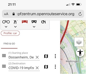
Find the route to your nearest Covid-19 vaccination center in Germany — new App by HeiGIT based on OpenStreetMap and openrouteservice
Where is is the closed Covid-19 vaccination center and what is the best way to get there? A new route planning app helps you answer this questions by suggesting ways to the nearest vaccination center. You can use this route … Read More
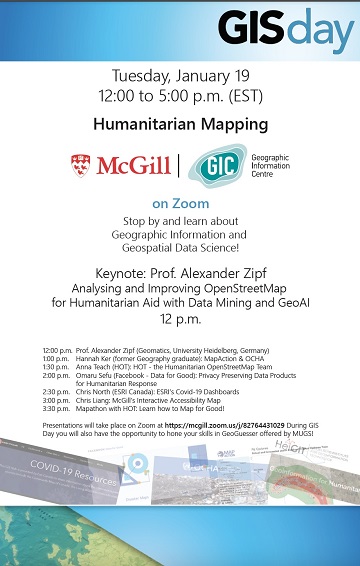
Keynote at McGILL GIS DAY: Analysing and Improving OpenStreetMap for Humanitarian Aid with Data Mining and GeoAI
Prof. Alexander Zipf has been invited to give the keynote at GIS DAY 2021 at McGILL University (Montréal, Canada) on Tuesday 19. Jan. 2021. The theme of the whole GIS Day at McGill is Humanitarian Mapping and the talk will … Read More
Update on “Accessibility of COVID-19 vaccination centers in Germany”
Based on newly available locations for missing COVID-19 vaccination centers the accessibility analysis has been updated.
Accessibility to pharmacies in Germany with 15km Covid-19 restriction
Current lockdown regulations in Germany state that – in many but not all federal states – travel in COVID-19 hotspot regions is only allowed up to 15km distance. This has raised concerns since a 15km radius has been perceived by … Read More
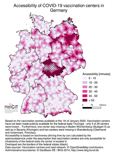
Accessibility of covid-19 vaccination centers in Germany
Vaccination of a sufficiently large share of the population is considered the most important action to fight the spread of SARS-CoV -2 and resulting COVID-19 infections. Germany has started together with the majority of EU member states at the 27th … Read More
HeiGIT participates at virtual HOT Summit 2020
Next week the HOT Summit will take place. The conference takes already place for the sixth time and it is the fifth consecutive time that we from HeiGIT/GIScience Heidelberg do contribute a session. This years topic is 10 Years of … Read More
New Jupyter Notebook: Analysis of Access to Health Care using openrouteservice Isochrones API
What is the idea behind the Notebook? In the case of an emergency (e.g. floods, earthquakes, political crisis) it is important to know where the health facilities are located. Furthermore, it is important to identify which cities/districts have a reduced … Read More
Exploring Localness of OSM Data – An Analysis using the OSHDB and ohsome api
“Local Knowledge” is constituting the exceptional value of Volunteered Geographical Information and thus also considered as an important indicator of data quality. We are interested in how much local information is captured in OpenStreetMap data. In this blog post we … Read More