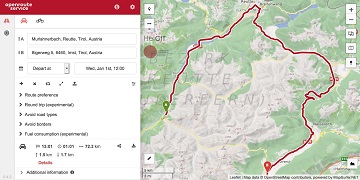
Since some time the City of Karlsruhe uses the API of Openrouteservice (ORS) by HeiGIT for routing of pedestrians, bicycles and cars in the new online city plan and the…
#Noise #pollution is one of the main stressors in urban environments, having negative impacts on people’s quality of life and health. For some groups of citizens, such as school children,…
Vom 06. bis zum 08. Juli fand das Online Symposiums “COVID-19 als Zäsur? Geographische Perspektiven auf Räume, Gesellschaften und Technologien in der Pandemie” statt. Teilnehmer aus Geographie, Medizin, Public health…
Today (1st July 2020) marks the first birthday of HeiGIT gGmbH! Over this first year, HeiGIT has been involved a large number of events, projects, publications, and press coverage. Founded…
Using hospital locations and the ORS Isochrone service, we have created a method for comparing physical access to healthcare in Sub-Saharan Africa. Hospital locations were derived from OpenStreetMap and compared…
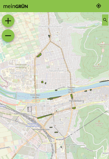
Today the time has come: The “meinGrün” web app for Dresden and Heidelberg is officially launched. With the mobile application you can (re-)discover known and unknown green spaces and find…
Sveriges Television AB (the public Swedish television company) has published a data journalism WebApp showing how far one can travel according to the recommendations from the Swedish Public Health Authority….
We are thrilled to give you a sneak peak into routing with time-dependent road restrictions, the outcome of our collaboration with GraphHopper GmbH in the research project TARDUR supported by…
Supplying medicine and food is critical not only in disasters. Due to increased global demand due to COVIDー19 HeiGIT increased the API quota for the Openrouteservice multi vehicle route optimization…
While naturally all of our features are already accessible via the openrouteservice API, we have now made some of the newer routing features accessible in our Maps Client on maps.openrouteservice.org….
Recently the UN Pulse Lab Jakarta has developed a disaster monitoring WebApp called the MIND/DisasterMon platform. According to UN Pulse Lab the objective of the MIND/DisasterMon platform is to try…
According to a recent post by NASA, researchers at NASA’s Goddard Space Flight Center in Greenbelt, Maryland, calculated the time that could have been saved if ambulance drivers and other…
We are pleased to announce the latest release of openrouteservice – version 6.0 also known as Ganymede. The main changes in this release are nestled in the backend code itself…
HeiGIT|GIScience HD beteiligt sich auch dieses Jahr am Fachaustausch geoActive (28.11.2019, 12.00 – 16.00 Uhr, halle02, Heidelberg) des GeoNet.MRN. In diesem Jahr werden wir als Teil des Open Space Konzeptes…
Last week was the Smart City Expo World Congress 2019 took place in Barcelona. Our region geoinformation network GeoNet.MRN was there with a booth presenting the members of GeoNet.MRN, among…
Over the last few days, Heidelberg’s first climathon event took place at EMBL, which was part of the global Climathon. The event ran from 25th-27th October 2019 with a 24…
Beim Konsortialtreffen letzte Woche haben wir die erste Beta Version der meinGrün App fertiggestellt. Jetzt benötigen wir Grünflächen-Enthusiasten, die mit uns zusammen die App testen, um sie weiter zu verbessern….
We are happy to share that GIScience Heidelberg/HeiGIT participate in the 1st Climathon in Heidelberg on Sat/Sun 26.-27. Oct 2019 at EMBL Heidelberg with a challenge on the following topic:…
Today we celebrate the International Day for #DisasterRiskReduction. HeiGIT offers a growing set of tools and services that support humanitarian aid during and before disasters. Examples include work in the…