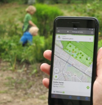
Urban green spaces (UGSs) can provide important ecosystem services for citizens and their well-being. To make use of these services according to UGS user demands, urban residents, tourists, and city administrations should know where UGSs are located, what qualities they … Read More
Deutsch
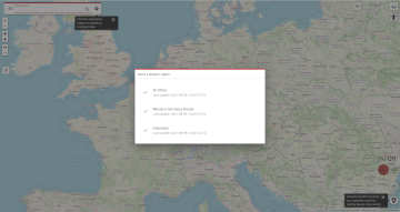
Revamped openrouteservice client for disaster management
We are happy to announce a revamped openrouteservice maps client for disaster management. It was built based on the new openrouteservice maps client, that is an open source route planner with plenty of features. Specific disaster features were incorporated via … Read More
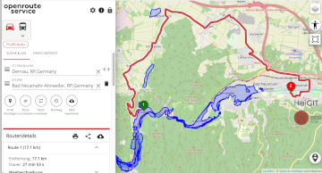
Routenplanung im Überflutungsgebiet: openrouteservice nutzt Copernicus EMS Flut-Daten in spezieller Lösung
Die aktuelle Flut in Deutschland hat zahlreiche Straßen in den betroffenen Gebieten zerstört oder temporär unpassierbar gemacht. HeiGIT arbeitet an freien und offenen, auf Geodaten-basierten Lösungen für die humanitäre Hilfe. Hierzu zählen insbesondere Routenplanung unter Berücksichtigung aktueller Katastrophendaten wie z.B. … Read More
HeiGIT/GIScience @ State of the Map 2021
Like in 2020, this year’s State of the Map (SotM) is taking place online this week from tomorrow 2021-07-09 to 2021-07-11, starting at 12:00 (CEST) each day. This year, HeiGIT is a bronze sponsor. In addition, there are a total … Read More
Openrouteservice for complex route optimization in new QGIS extension by Regionalverband Ruhr
Openrouteservice für komplexe Routenoptimierung in neuer QGIS-Erweiterung des Regionalverband Ruhr Der Regionalverband Ruhr (Team 9-2 Geodaten-Technik) hat mit einer neuen QGIS-Erweiterung das Potenzial von openrouteservice (ORS) von HeiGIT genutzt und eine weitere Anwendungsmöglichkeit für den ORS geschaffen: Das Tool “Verortung … Read More

GIScience and HeiGIT contributions to AGILE 2021 conference
The AGILE 2021 conference is taking place this week. It is the the 24rd AGILE conference on GIScience. AGILE is the Association of Geographic Information Laboratories in Europe and the 2021 conference is for the first time held as a … Read More
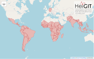
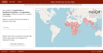
All countries of Central and South America now on Open Healthcare Access Map
After Sub-Saharan Africa and South and Southeast Asia we have now published all countries of Central and South America on the Open Healthcare Access Map. The web application is available here: https://apps.heigit.org/healthcare_access/. Please note that this is still a prototype … Read More
Die Stadt Mannheim nutzt openrouteservice für die Routenplanung in ihrem Online-Stadtplan
Seit kurzem nutzt die Stadt Mannheim openrouteservice (ORS) von HeiGIT für das Routing von Fußgängern, Fahrräder, Autos, LKW und Rollstuhlfahrern im Online-Stadtplan für die breite Öffentlichkeit, d.h. die Bürger und Besucher von Mannheim. Sie können es hier verwenden: https://www.gis-mannheim.de/mannheim/index.php?bl=wms_web_grau&service=mannheim<=mod_ors Dies … Read More
All countries of South and Southeast Asia now on Open Healthcare Access Map
It’s been a little longer than a month since we published the Open Healthcare Access Map. Last week we rolled out all countries of Sub-Saharan Africa. Today all countries of South and Southeast Asia follow. The web application is available … Read More
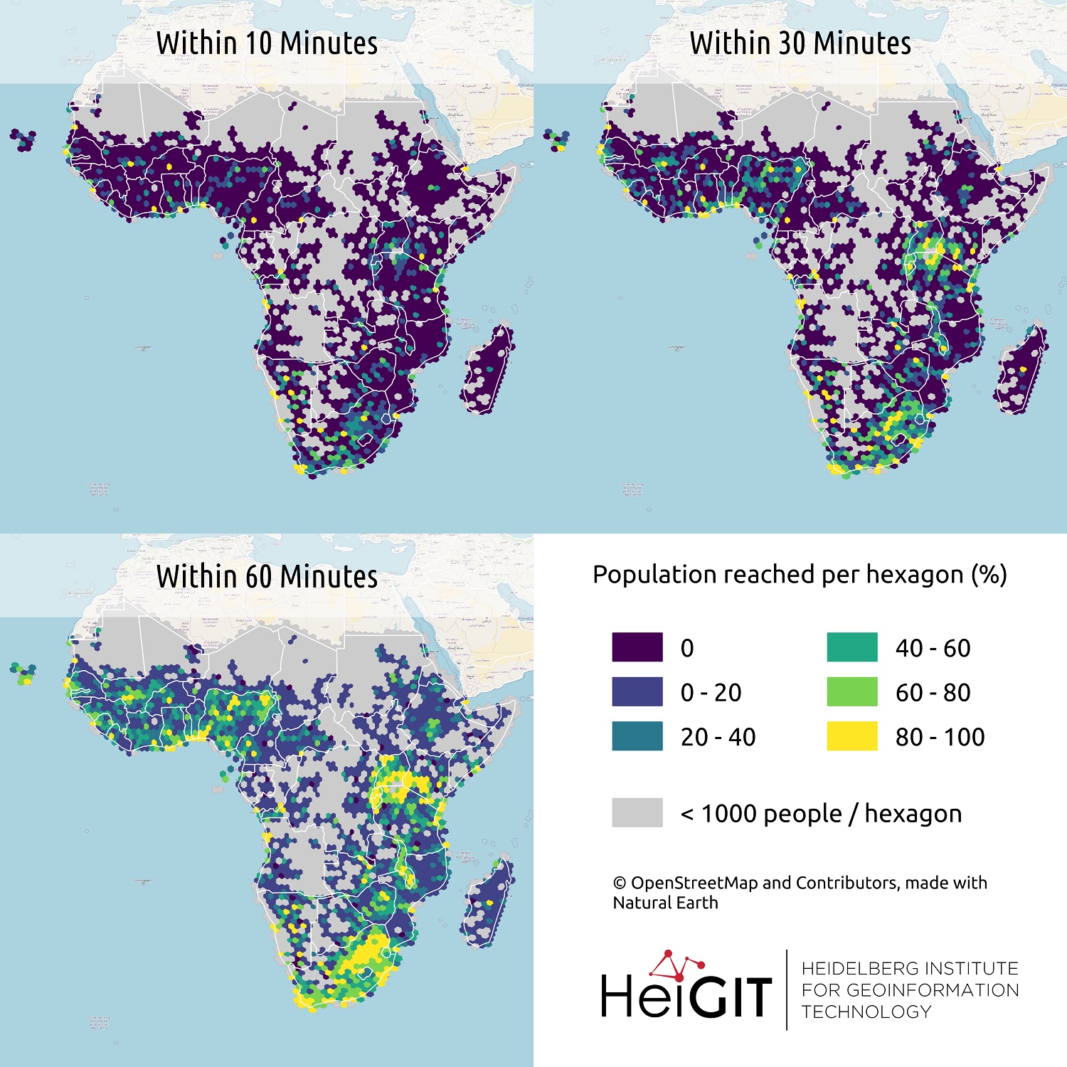
All countries of Sub-Saharan Africa now in Open Healthcare Access Map
Last month we started the Open Healthcare Access Map. Initially, only a few countries were featured. Gradually, more countries and regions are now being added. Today we release all countries of Sub-Saharan Africa. The web application is available here: https://apps.heigit.org/healthcare_access/. … Read More
SocialMedia2Traffic – Kick-Off presentation 13.04.21
Up-to-date traffic information is a prerequisite for navigation solutions to determine the best route and travel time. In the SocialMedia2Traffic project by HeiGIT and GIScience Heidelberg , conclusions about current traffic density and speed will be derived based on data … Read More
Open Position @ HeiGIT: Software Engineer OSM Routing Services – Backend & Algorithms
Sie lieben Open-Source-Geoinformationsdienste zu entwickeln, die täglich von Tausenden genutzt werden? Sie sind ein hochmotivierter Java Backend-Entwickler und Algorithmen-Designer? Und Sie wollen OpenStreetMap für leistungsstarke GI-Dienste mit globaler Abdeckung einsetzen und verbessern? Dann haben wir vielleicht einen passenden und interessanten … Read More
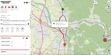
A fresh new ORS maps client
We are happy to announce that the new openrouteservice maps client has been finished and released. It is an open source route planner with plenty of features for car, heavy vehicles, hiking, cycling and wheelchair, designed to be mobile friendly … Read More
AUF DIREKTEM WEG ZUR CORONA-IMPFUNG – Meldung der Universität Heidelberg
Die Universität Heidelberg berichtet aktuell über impfzentrum.openrouteservice.org NEUER ROUTENPLANER ERMITTELT DEUTSCHLANDWEIT DIE SCHNELLSTE ROUTE ZUM NÄCHSTEN IMPFZENTRUM Wo kann ich mich gegen das Coronavirus impfen lassen und wie komme ich dorthin? Diese Frage beantwortet ein von Geoinformatikern der Universität Heidelberg … Read More
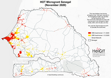
Updated OSM Healthcare in Senegal (2020)
OpenStreetMap (OSM) offers many possibilities and holds potential in the area of freely available infrastructure data for the health sector. Nevertheless, it is important to underline that the quality of the information is different in each country, since the mapping … Read More
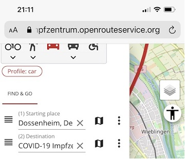
Find the route to your nearest Covid-19 vaccination center in Germany — new App by HeiGIT based on OpenStreetMap and openrouteservice
Where is is the closed Covid-19 vaccination center and what is the best way to get there? A new route planning app helps you answer this questions by suggesting ways to the nearest vaccination center. You can use this route … Read More
Update on “Accessibility of COVID-19 vaccination centers in Germany”
Based on newly available locations for missing COVID-19 vaccination centers the accessibility analysis has been updated.
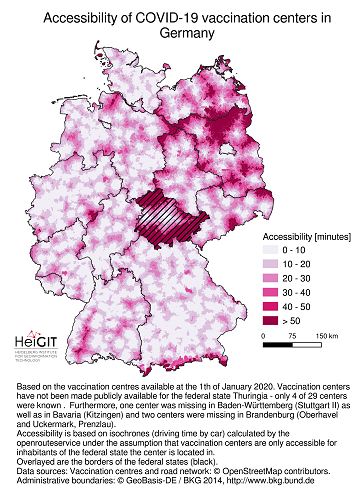
Accessibility of covid-19 vaccination centers in Germany
Vaccination of a sufficiently large share of the population is considered the most important action to fight the spread of SARS-CoV -2 and resulting COVID-19 infections. Germany has started together with the majority of EU member states at the 27th … Read More
New Jupyter Notebook: Analysis of Access to Health Care using openrouteservice Isochrones API
What is the idea behind the Notebook? In the case of an emergency (e.g. floods, earthquakes, political crisis) it is important to know where the health facilities are located. Furthermore, it is important to identify which cities/districts have a reduced … Read More
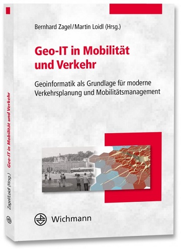
Optimal ans Ziel: Routing-Dienste auf Basis nutzergenerierter Geodaten
Ein neues Buch gibt in einem Buchkapitel einen Überblick der vielfältigen Aktivitäten von HeiGIT und GIScience im Bereich Routenplanung und Navigation. Neben Grundlagen (wie schnelle Routing-Algorithmen) zur Umsetzung werden vor allem diverse Anwendungsbeispiele für flexible Routing-Dienste in Spezialanwendungen vorgestellt. Hierzu … Read More