Charles Hatfield will represent HeiGIT at the first ever African Transport Research Conference (ATRC 2024) which takes place from March 5-7 in Capetown, South Afrika. The conference was established to address rapid urbanisation in Africa and the corresponding challenges for … Read More
Blog
IDEAL-VGI: Analyzing and Improving the Quality and Fitness for Purpose of OpenStreetMap as Labels in Remote Sensing Applications
We are happy to announce that the IDEAL-VGI project by GIScience has been successfully completed. IDEAL-VGI was a tandem project in cooperation with Begüm Demir from the TU Berlin and was conducted under the umbrella of the VGIscience Second Phase … Read More
HeiGIT International Postdoctoral Fellowships for GIScience Research for Climate Action
Dear Postdoctoral Scholars and Researchers, You are a highly motivated researcher who loves spatial data science and open geodata? You want to use your expertise for the benefit of society and the environment – in particular stimulating Climate Action or … Read More
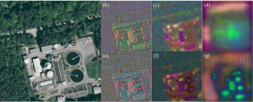
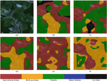
GeoAI4Water 2 Applies Deep Learning to Detect Critical Infrastructure for Disaster Planning
Context During natural disasters and other catastrophic events, quickly identifying and distributing resources is essential. Even a brief delay in evacuating residents or sourcing water can significantly hamper relief efforts and prevent effective disaster management. The HeiGIT and GIScience teams … Read More
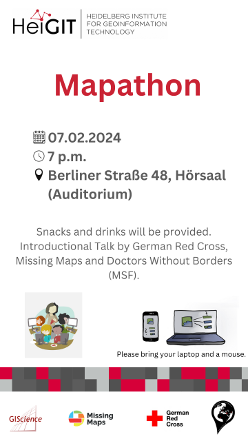
Mapathon on February 7th
The first Mapathon this year will be on February 7th. When: Wednesday, 07.02.2024, at 7 p.m. Where: Berliner Straße 48, Hörsaal After a short introduction into the region and subject of this mapping task, you will also get instructions how … Read More
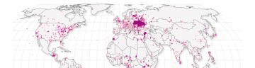
Analyzing the Changesets of OSM Newcomers
A new rate limit is introduced The OpenStreetMap (OSM) API recently introduced a rate limit, which is designed to limit the impact of a particular kind of map vandalism: new users signing up and mass editing OSM data, e.g. by … Read More
Spotlight on HeiGIT’s FOSSGIS 2024 Presentations
We’re thrilled to share some exciting news – our colleagues Julian Psotta and Benjamin Herfort are set to deliver talks at FOSSGIS 2024 in Hamburg, Germany! Julian Psotta will be presenting the openrouteservice project together with the Federal Agency for … Read More
Advancing Climate Action: HeiGIT’s New Climate Action Team
HeiGIT is embarking on an initiative to address one of the most critical challenges of our time — climate change. We are proud to announce the commencement of the Climate Action Readiness Initiatives funded by the Klaus-Tschira Stiftung. These initiatives … Read More
GeoPrompt – Revolutionizing Navigation and Beyond: HeiGIT’s Innovative Web Application Powered by ChatGPT
Introduction In an era where technology continuously reshapes our world, the fusion of artificial intelligence and geospatial data offers exciting possibilities. HeiGIT (Heidelberg Institute for Geoinformation Technology), a pioneering research organization, has unveiled a novel web application that not only … Read More
‘Waterproofing Data’ Project wins ESRC Celebrating Impact Prize 2023
The “Waterproofing Data” project has won the ESRC Celebrating Impact Prize 2023 in the category “Outstanding Societal Impact” for helping to protect residents of flood-prone areas in Brazil. In 2018, Joao Porto de Albuquerque from the University of Glasgow initiated … Read More
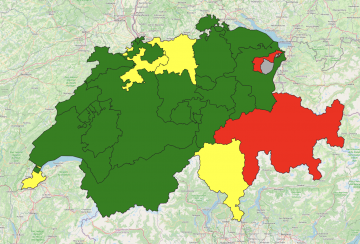
OQT for Food Environments
HeiGIT and the Amsterdam University Medical Center (UMC) partnered up to investigate food environments through the lens of OpenStreetMap (OSM) data. UMC analyses how exposure to different categories of food related retailers affects health matters. The assumption is that the … Read More
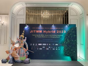
Joint International Tropical Medicine Meeting 2023
GIScience member and PhD candidate Steffen Knoblauch was invited as a speaker at the Joint Internationl Tropical Medicine Meeting (JITMM) 2023. The conference’s focal topic was “Achieving the SDGs: Human and AI-driven Solutions for Tropical Medicine in a Changing World” … Read More
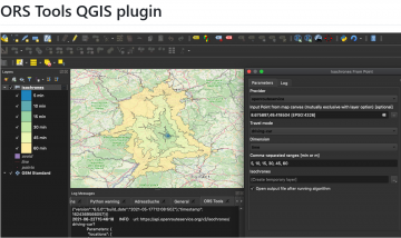
ORS Tools QGIS Plugin Release v1.7.0
Just in time for the new year, the openrouteservice team proudly announces the release of v1.7.0 of the ORS Tools QGIS plugin! Quite a lot has happened. First, the GUI was reworked: Manually created points can be saved into a … Read More
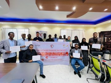
Somaliland GIS Training
Since 2022, HeiGIT is providing technical support to the Somali Red Crescent Society (SRCS) in Somalia. The objective was the development of an Early Action Protocol (EAP) for droughts in Somalia, a plan developed by RCRC National Societies that outlines … Read More

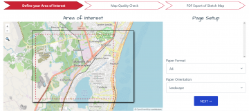
Introducing OhsomeNowStats
Today, we’d like to shine a light on the online tool OhsomeNowStats. OhsomeNowStats allows users to take a look at the mapping activity in OpenStreetMap. This is especially useful for humanitarian organizations and mapathon organizers, because OhsomeNowStats data is updated … Read More
IT Systems Engineer (m/f/d, up to 100%)
Are you passionate about automation, monitoring and the development of innovative IT infrastructures? Are you an enthusiast for open source software? And would you like to work with developers and researchers to further develop software in the field of geoinformatics … Read More
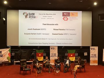
Looking back at SOTM Africa and Missing Maps Gathering
The recently concluded State of the Map Africa 2023, hosted in Yaoundé, Cameroon, marked the fourth edition of this regional OpenStreetMap (OSM) conference. The State of the Map was a great opportunity to get to know the people who are … Read More
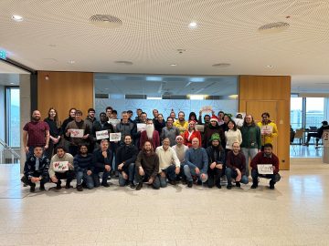
The Year 2023 at HeiGIT
As 2023 is coming to an end, we would like to take the opportunity to look back at this eventful year and appreciate the advance that HeiGIT has made towards its goal of enabling and improving the transfer of knowledge … Read More
HeiGIT-Team Wins “Open Source Software for Sustainable Development Goals (OSS4SDG)” Hackathon
The HeiGIT team recently secured the top position in the third edition of the Open Source Software for Sustainable Development Goals (OSS4SDG) hackathon. These hackathons are based on the 17 Sustainable Development Goals (SDGs) of the UN. The participants were … Read More
Student Assistant (m/f/d) for Communication Tasks
Our team is currently looking for: Student Assistant (m/f/d) for Communication Tasks Your tasks will be to support the openrouteservice team in communication tasks with our users. Your Tasks will mostly be email communication and answering inquiries in our community … Read More