After introducing the OSM Element Vectorisation Tool last week, we now want to show possible use cases and specific examples of what the tool can do. This second of three…
After introducing the OSM Element Vectorisation Tool earlier this week, we now want to show possible use cases and specific examples of what the tool can do. This first of…
The IDEAL-VGI research project is nearing its end. And while that won’t be the end of our research into social data sources, data quality analyses and land-use information, we are…
Sketch Map Tool (SMT) – An easy-to-use way to create and digitalize paper maps for offline data collection in the field The HeiGIT (Heidelberg Institute for Geoinformation Technology) team recently…
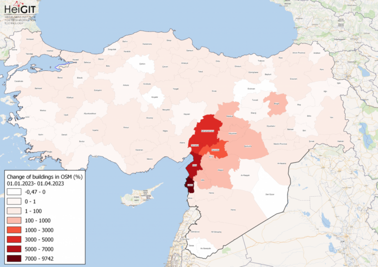
Featured Map: Percent change in each province of Türkiye and Syria of buildings in OSM. Data from OpenStreetMap, visualized using QGIS and the ohsome API plugin. Welcome back to the…
Featured Image: Figure 1. Total carbon fluxes related to LULCC in Baden-Württemberg between March 2018 and October 2019 (LaVerDi, OSMlanduse+), and March 2018 and March 2020 (OSMlanduse, OSMlanduse cleaned). The…
Since the transportation sector is one of the major greenhouse gas (GHG) emitters that has not seen significant emission reductions in the last decades, it requires special attention from policymakers….
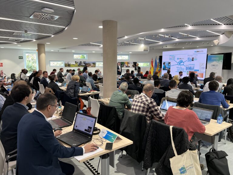
The United Nations Maps program, created in 2019, held its 2nd UN Maps Conference, this time in Valencia, Spain. Prof. Alexander Zipf of HeiGIT and the GIScience Research Group at…
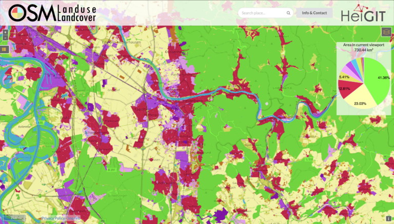
We are pleased to announce that https://osmlanduse.org has received a functionality update. Thanks to the cooperation of GIScience and HeiGIT under the IDEAL-VGI project, our researchers were able to add…
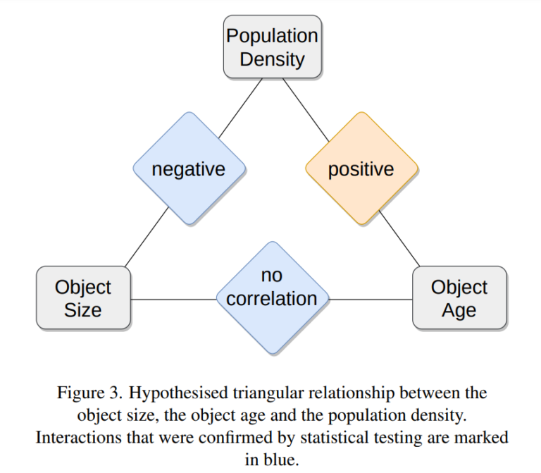
Featured Image: Figure 3 from paper. One of the contributions showcased by the HeiGIT/GeoScience team in last year’s Free and Open Source Software for Geospatial (FOSS4G) 2022 conference was Moritz…
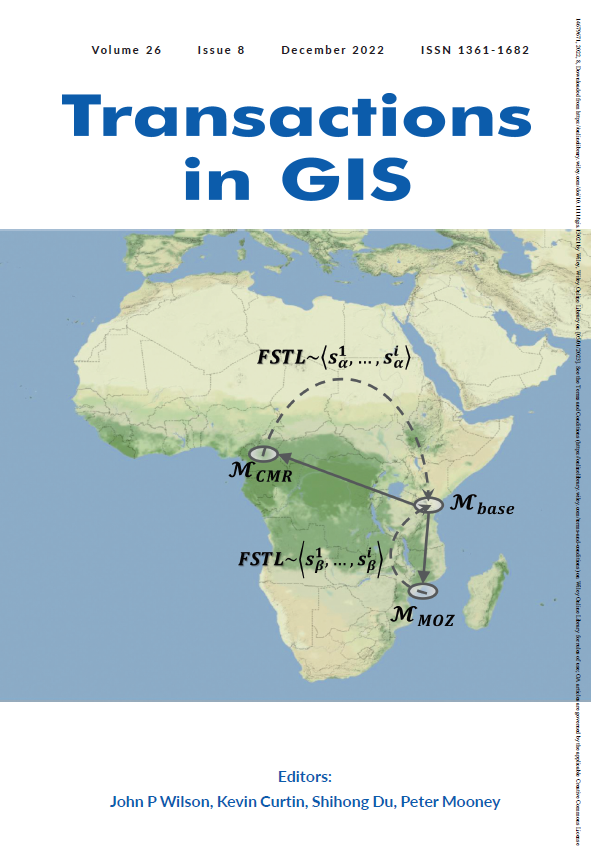
Volume 26, Issue 8 of Transactions in GIS, published in December 2022, has a cover story and it’s us- well, our article anyway. Besides uniting our love of math, mapping,…
If you’re on the job market or know someone who is, check out this exciting new opening from our partners at GIScience. The offer is included as text below. You…
Featured Photo: Ohsome dashboard interface for Heidelberg, Germany. In the words of Confucius, “The man who moves a mountain begins by carrying away small stones.” As we release OSHDB (OpenStreetMap…
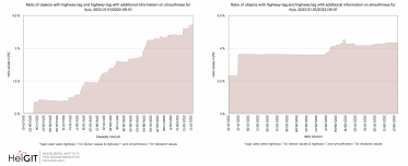
As of 02.11.2022 we have reached objects 10,107,826,483* in our oshdb. As such, we think it is most definitely time to celebrate! *For information on the background this figure, read…
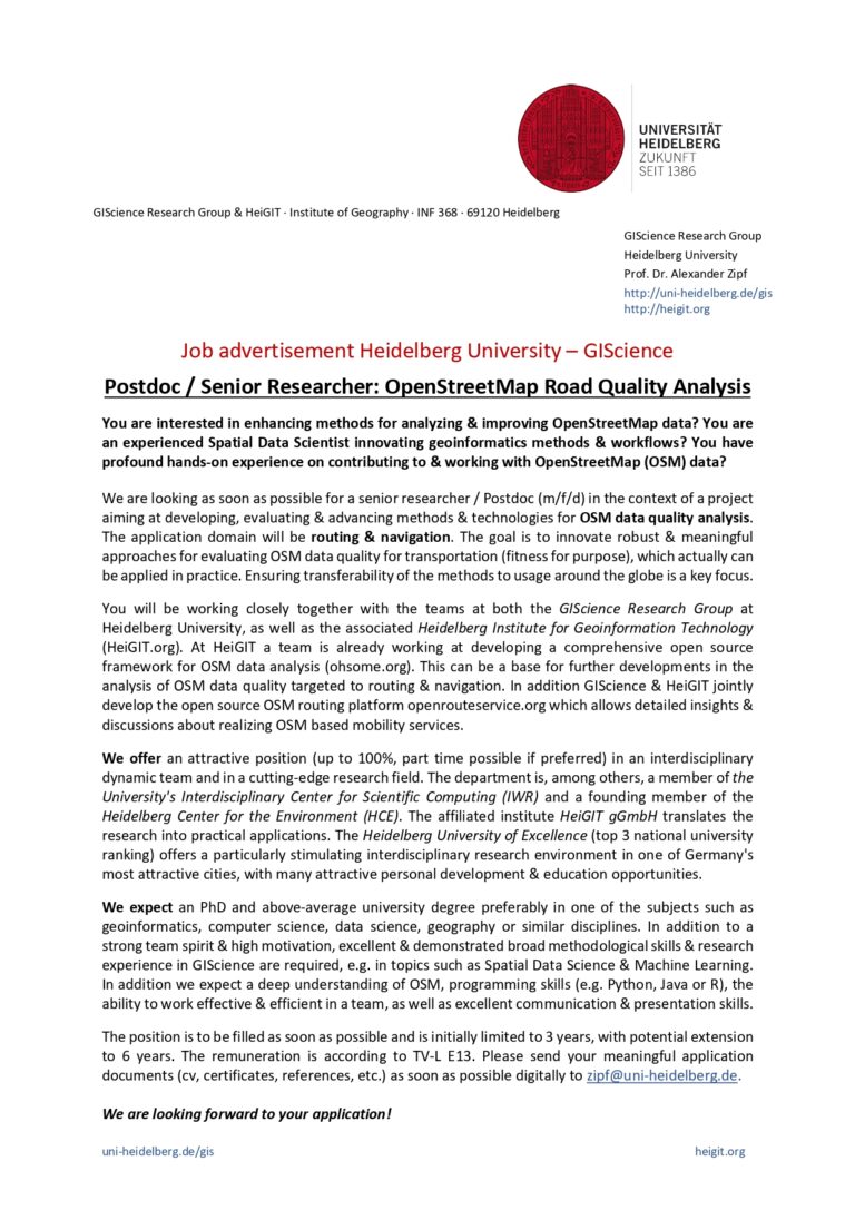
Welcome back to our ohsome region of the month series! In this post, we’ll take a look at the temporal development of highways and added smoothness-information, as well as social…
We have exciting ohsome news! As many of you know, past OSHDB updates happened weekly and led to a delay between the data in OpenStreetMap (OSM) and our database. Basically,…
Introduction Since the release of the ohsome quality analyst (short OQT) in February of last year, we have been working on developing an accessible yet powerful toolkit which provides end…
Hello again and welcome back to our “How to become ohsome” series where we demonstrate how you too can become ohsome with ohsome API! If you’re new to the series…
At long last, welcome to another addition of our How to become ohsome-series! This one is special because we’re discussing a third-party application that uses ohsome API as back-end to…
Welcome back to a new installment of the ohsome Region of the Month blog series! This will be part two our posts on hiking related tags and this time, we’ll…

![Figure 1. Total carbon fluxes related to LULCC in Baden-Württemberg between March 2018 and October 2019 (LaVerDi, OSMlanduse+), and March 2018 and March 2020 (OSMlanduse, OSMlanduse cleaned). The upper plot shows the relative difference of carbon fluxes [%] with respect to LULC transition and carbon flux attribution method. The carbon fluxes of method 1 are set to 0. The lower plot shows the total absolute carbon fluxes [Mg C] calculated with carbon flux attribution method 1 with respect to LULC transition and LULCC method.](https://heigit.org/wp-content/uploads/2023/05/ed501d68-7952-4263-a23e-a5f8a81fa7a4-768x873.png)