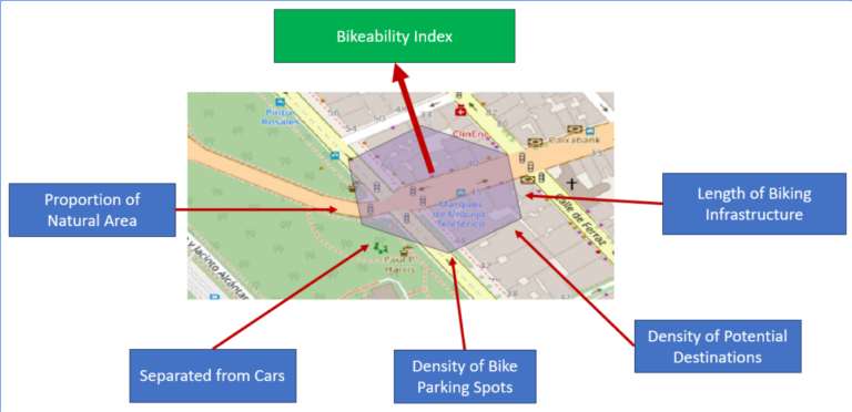
For various reasons biking is becoming a more frequently used mode of transportation. It offers flexibility, is quite cheap compared to other modes of transportation, helps with fitness and is…
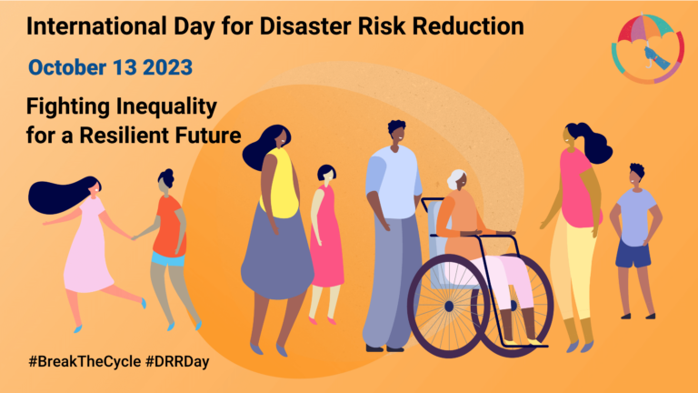
Did you know that October 13th is the International Day for Disaster Risk Reduction (IDDRR)? Since 1989, the United Nations Office for Disaster Risk Reduction promotes a global culture of…
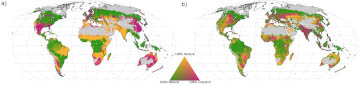
Re-arranging food production: How we could use the vegetation zones on our planet more efficiently Imagine we could almost double the amount of crops we grow on our planet, while…
The Sketch Map Tool (SMT) is entering its next project phase thanks to support from the German Red Cross (GRC) and the German Federal Foreign Office. In this phase, our…
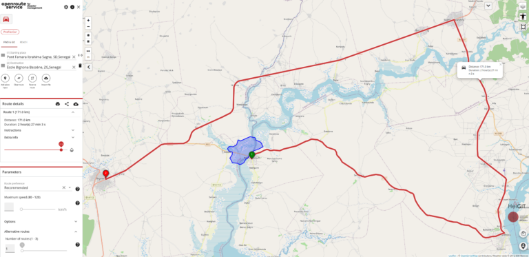
In the context of disaster management, time is of the essence. Quick and accurate response can make all the difference in saving lives and mitigating damage. That’s why the openrouteservice…
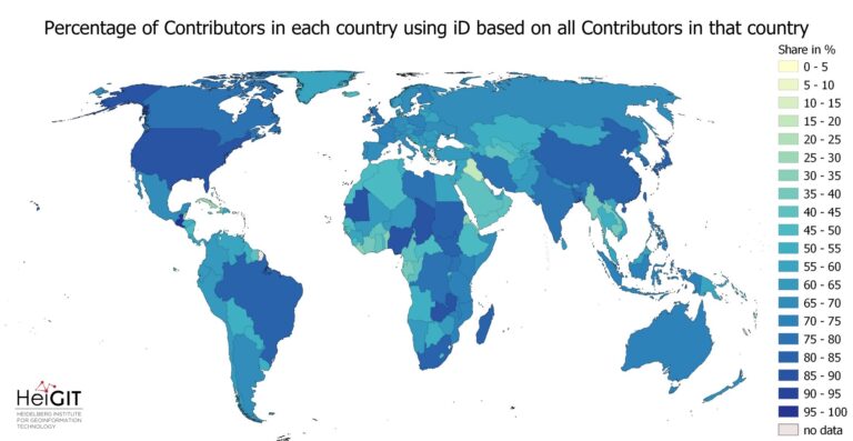
At HeiGIT and in particular within the ohsome team, we strive to provide valuable insights into OpenStreetMap (OSM) data. The ohsome API offers aggregated statistics on the evolution of OSM…
Until recently, Nina Krašovec was a research assistant at the GIScience research group. This article is the result of an interview, where she spoke about her work at the time…
Did you know that the OpenStreetMap (OSM) taginfo site now lets you access the ohsome dashboard? This allows you to gain refined insights into the usage stats of specific keys…
Campus reporter Nils Birschmann spoke with Prof. Alexander Zipf about our Disaster Portal. The interview was broadcast on Radio Regenbogen. You can listen to the full length of the…
Using the ohsome dashboard, it is possible to explore quality estimation for OpenStreetMap (OSM) data from the ohsome quality analyst (OQT) for arbitrary regions. Also, OQT does provide an API…
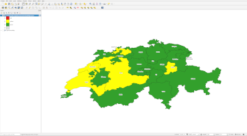
In his bachelor’s thesis, supervised by HeiGIT’s apl. Prof. Dr. Sven Lautenbach, Lars Reckhaus examined the suitability of OpenStreetMap (OSM) for location analyses in the context of residential real estate…
You can now monitor contributions to OpenStreetMap (OSM) in real time with ohsomeNow stats! We developed this new dashboard as part of our long-term cooperation with the Humanitarian OpenStreetMap Team…
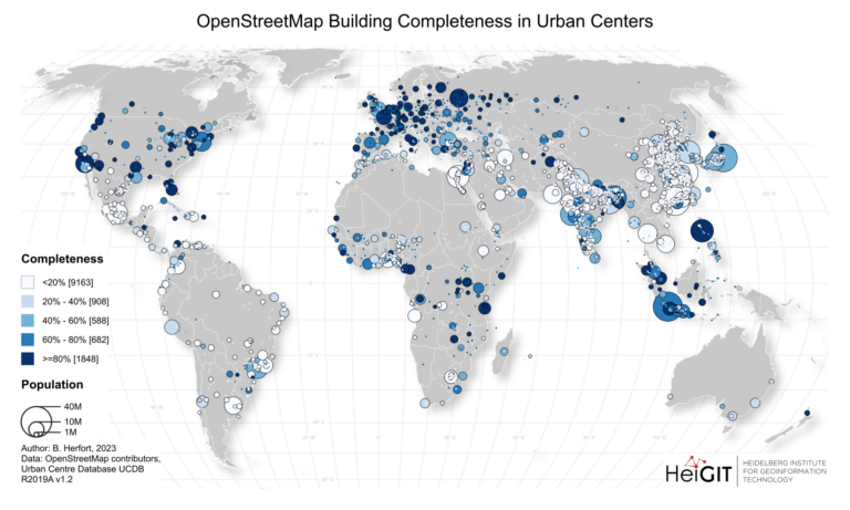
Exploring OSM editor statistics by combining data from OSHDB and changeset DB OpenStreetMap (OSM) marks one of the most successful and powerful open source, crowdsourced geomaps, with over 10 million…
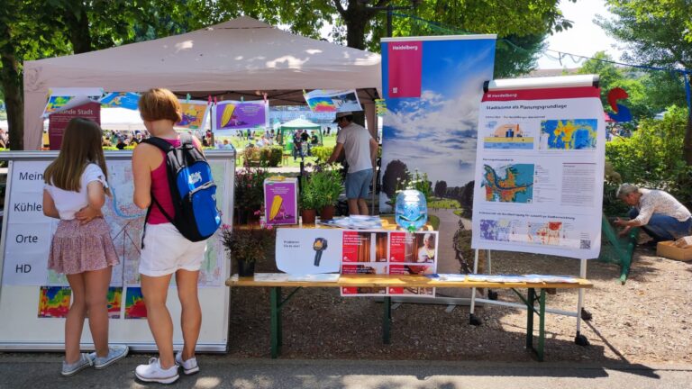
The transdisciplinary project HEAL involves citizens in the research process on heat stress in the city: The aim is to make everyday life easier for at-risk groups during heat waves….
In context of his research on mosquito monitoring and inner-urban dengue occurence, PhD student and GIScience team member Steffen Knoblauch visited the “Universidade Federal Fluminese” (UFF) in Niterói, State of…
Insights from GIScience-CSIAD Collaboration – a conference recap Recently, Hanse-Wirtschaftskolleg hosted its meeting which brought together experts from GIScience and CSIAD lab, along with renowned researchers from universities in Germany,…
Aner Martinez-Soto, Johannes Fürle and Alexander Zipf published the paper “Urban Heat Island Intensity Prediction in the Context of Heat Waves: An Evaluation of Model Performance”. It was presented at…
Benjamin Herfort and his colleagues Sven Lautenbach, João Porto de Albuquerque, Jennings Anderson and Alexander Zipf published an article in the renowned journal Nature Communications (Impact Factor 2023: 17.7). In…
The ohsome dashboard has been and continues to be an easy access point to generate accurate statistics about the historical development of OpenStreetMap data for arbitrary regions. Now, the ohsome…
On 27th June 2023, Oliver Fritz and Sabrina Marx from HeiGIT’s Geoinformation for Humanitarian Aid team joined their colleagues of the Alfred Wegener Institute (AWI) in Potsdam for a workshop…