During catastrophic events such as the recent Türkiye/Syria earthquake, the road infrastructure in the affected area is often widely interrupted and accessibility varies over time. In spite of this, it is imperative to quickly provide assistance to the affected people. … Read More
Blog
HeiGIT to hold hands-on workshop about OSM data quality at FOSSGIS Berlin 15.-18.03.2023
HeiGIT will present its software “ohsome quality analyst” (OQT) at the FOSSGIS Conference in Berlin this week. In the demo session, Benjamin Herfort will show the numerous possibilities of the tool and how everyone can use OQT to evaluate completeness, … Read More
HeiGIT, DLR & GRC’s Cooperation Workshop February 27-28 in Berlin
The German Red Cross (GRC) has been working with the Heidelberg Institute for Geoinformation Technology (HeiGIT gGmbH) and the German Aerospace Center (DLR) for several years to bridge the gap between research and practice by identifying needs and developing technological … Read More
An ohsome R package on CRAN
Our ohsome R package has finally landed on CRAN! The package grants access to the power of the ohsome API. This makes it even easier to analyze the rich data source of OpenStreetMap (OSM) history from R. You can specify … Read More
Poster Preview for the UN Maps Conference
In this space, we have uploaded our two posters and their contents for this week’s UN Map Conference in Valencia, Spain on March 6-10, 2023. Our poster highlights three major case studies from HeiGIT and GIScience with applications for researchers, … Read More
Official Launch of the Sketch Map Tool
Last Wednesday we were excited to present the new version of the Sketch Map Tool in an online launch event! We thank all participants for joining and for their feedback as well as their interest in being involved in the … Read More
OpenStreetMap Element Vectorisation: A Tool for High Resolution Data Insights and its Usability in the Land-use and Land-cover Domain
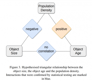
Featured Image: Figure 3 from paper. One of the contributions showcased by the HeiGIT/GeoScience team in last year’s Free and Open Source Software for Geospatial (FOSS4G) 2022 conference was Moritz Schott, Sven Lautenbach, Leonie Großchen, and Alexander Zipf’s novel paper … Read More
Sketch Map Tool Launch
We are excited to invite you to the official launch of the Sketch Map Tool! The Sketch Map Tool is an easy-to-use, open-source and free-of-charge tool which facilitates community mapping. You can use it to collect local spatial knowledge with … Read More
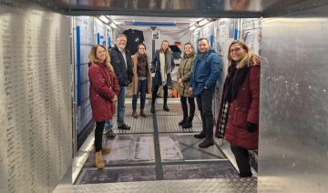
Cooperation between HeiGIT, the German Red Cross and the German Aerospace Center
Cover image: Team representatives from German Red Cross, DRL and HeiGIT in the replica of the European research capsule COLUMBUS, which is part of the International Space Station (ISS). Photo by Anne Schneibel, Jan. 24, 2023. Which buildings are most … Read More
Disaster openrouteservice to support the current response efforts to the Türkiye/Syria earthquake
On February 6, a 7.7 magnitude earthquake struck southern Türkiye at 4:17 a.m. This is Türkiye’s most powerful earthquake recorded since 1939. The Government of Türkiye has since issued a Level 4 alarm, calling for international assistance. The quake also … Read More
Workshop on Centrality Indicators in Road Network Analysis: from concept to implementation
Centrality indicators are used to identify important nodes or edges in graph networks. Applied to road networks these indicators can for example be used to model traffic speed or identify critical roads to support disaster preparedness. Still, open challenges remain … Read More
Job Offer: Studentische Hilfskraft (m/w/d) im HeiGIT Team Support
Studentische Hilfskraft (m/w/d) im HeiGIT Team Support Liebe Studierende, wir suchen am HeiGIT baldmöglichst eine studentische Hilfskraft (32-40h/Monat) zur Unterstützung in administrativen und organisatorischen Tätigkeiten. Die HeiGIT gGmbH ist ein gemeinnütziges Start-up mit dem Ziel des Technologietransfers und der angewandten … Read More
Job Offer: Deep Learning Engineer (m/f/d, up to 100%)
Are you a highly motivated individual who loves designing and developing machine learning and deep learning systems? Do you want to use your machine learning expertise for the benefit of society and the environment? Do you want to improve the … Read More
Press Release: New tool allows look into the history of OpenStreetMap
With the OSHDB Ver. 1.0, the Heidelberg Institute for Geoinformation Technology (HeiGIT) releases a professional software that enables analyzing and visualizing of OpenStreetMap data development via a simple dashboard. Heidelberg, January 12, 2023. Two clicks. That’s all it takes to … Read More

Cover Story: Improving OpenStreetMap missing building detection using few-shot transfer learning in sub-Saharan Africa
Volume 26, Issue 8 of Transactions in GIS, published in December 2022, has a cover story and it’s us- well, our article anyway. Besides uniting our love of math, mapping, and Mozambique, we’re hoping to use our moment of fame … Read More
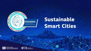
HeiGIT Team Shortlisted for Open Source Software for SDG (OSS4SDG) Challenge- Live Awards Ceremony December 7
Photo from event organizers @EU_DIGIT This week, HeiGIT is on the edge of our seats. Last month, a team at HeiGIT participated in the Open Source Software for SDG (OSS4SDG) Challenge organized by the United Nations Office of Information and … Read More
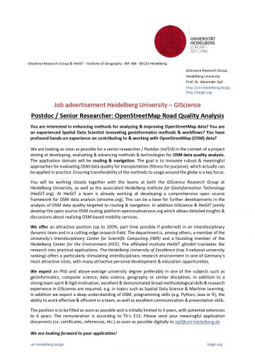
GIScience Postdoc/Senior Researcher Opportunity for OpenStreetMap Road Quality Analysis
If you’re on the job market or know someone who is, check out this exciting new opening from our partners at GIScience. The offer is included as text below. You are interested in enhancing methods for analyzing & improving OpenStreetMap … Read More

Assessing road criticality and loss of healthcare accessibility during floods: the case of Cyclone Idai, Mozambique 2019
Featured Image: Road network analysis for the driving profiles. A Normal conditions before the flood event. B Evolution of scores after the floods induced by Cyclone Idai. The lower row shows a close-up of the area surrounding the city of Dondo The ability of … Read More
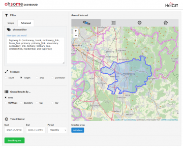
OSHDB Version 1.0 Has Arrived
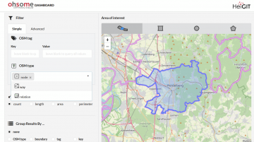
Featured Photo: Ohsome dashboard interface for Heidelberg, Germany. In the words of Confucius, “The man who moves a mountain begins by carrying away small stones.” As we release OSHDB (OpenStreetMap History Database) Version 1.0, we look back at versions 0.5, … Read More
Job Opening for Postdoc / Senior Researcher on OpenStreetMap Road Quality Analysis
If you’re on the job market or know someone who is, check out this exciting new opening from our partners at GIScience. The offer is included as text below! You are interested in enhancing methods for analyzing & improving OpenStreetMap … Read More