Sketch Map Tool (SMT) – An easy-to-use way to create and digitalize paper maps for offline data collection in the field The HeiGIT (Heidelberg Institute for Geoinformation Technology) team recently launched a new version of the Sketch Map Tool – … Read More
Blog
2022 #30DayMapChallenge Round-Up Part 2: Deleted Maps
Featured photo: The deleted map displays all deleted elements within the analyzed areas (red). Gray rectangles represent deleted buildings. This past November, our teams at HeiGIT and GIScience participated in Topi Tjukanov’s Twitter event #30DayMapChallenge, where mappers display their creativity … Read More
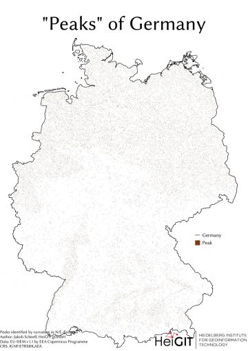
#30DayMapChallenge Round-Up Part 1: Germany Three Ways
Featured Image: The peaks of Germany identified by curvature in N/E direction, Jakob Schnell’s contribution for Day 7 (Raster) of the #30DayMapChallenge. This past November, our teams at HeiGIT and GIScience participated in Topi Tjukanov’s Twitter event #30DayMapChallenge, where mappers display … Read More
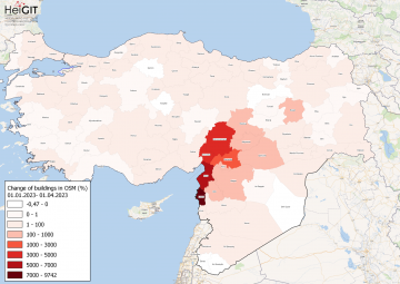
How to become ohsome part 15- Analysing Changes in OSM after the Earthquake in Syria and Türkiye in February 2023
Featured Map: Percent change in each province of Türkiye and Syria of buildings in OSM. Data from OpenStreetMap, visualized using QGIS and the ohsome API plugin. Welcome back to the how to become ohsome series! If you’re new to the series, … Read More
Training on digitalization of participatory mapping in Kuala Lumpur
Last week, HeiGIT team member Anne Schauß held a workshop session in Kuala Lumpur, Malaysia, during a training of the International Federation of Red Cross and Red Crescent Societies (IFRC). The international training focused on community resilience and how to … Read More
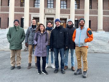
GeoEPI at CGA Conference: From Geospatial Research to Health Solutions
Featured photo: The geoEpi team attending CGA 2023. Back row from left: PD Dr. med. Thomas Jaenisch, Assoz. Prof. Dr. Bernd Resch, Dorian Arifi and Steffen Knoblauch. Front row from left: Dr. rer. nat. Ivonne Morales Benavides, Apl. Prof. Dr. … Read More
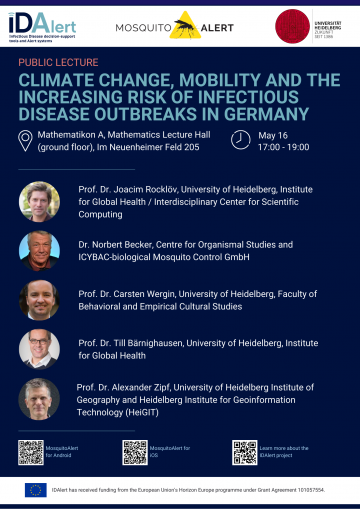
Upcoming Public Lecture May 16: Climate Change, Mobility, and the Increasing Risk of Infectious Disease Outbreaks in Germany
On Tuesday, May 16, visitors to the public lecture “Climate Change, Mobility, and the Increasing Risk of Infectious Disease Outbreaks in Germany” will be treated to insights from five experts currently pioneering research into one of the greatest threats to … Read More
![Figure 1. Total carbon fluxes related to LULCC in Baden-Württemberg between March 2018 and October 2019 (LaVerDi, OSMlanduse+), and March 2018 and March 2020 (OSMlanduse, OSMlanduse cleaned). The upper plot shows the relative difference of carbon fluxes [%] with respect to LULC transition and carbon flux attribution method. The carbon fluxes of method 1 are set to 0. The lower plot shows the total absolute carbon fluxes [Mg C] calculated with carbon flux attribution method 1 with respect to LULC transition and LULCC method.](https://heigit.org/wp-content/uploads/2023/05/ed501d68-7952-4263-a23e-a5f8a81fa7a4-360x409.png)
New Paper: Carbon Fluxes Related to Land Use and Land Cover Change in Baden-Württemberg
Featured Image: Figure 1. Total carbon fluxes related to LULCC in Baden-Württemberg between March 2018 and October 2019 (LaVerDi, OSMlanduse+), and March 2018 and March 2020 (OSMlanduse, OSMlanduse cleaned). The upper plot shows the relative difference of carbon fluxes [%] … Read More
Student Assistant (m/f/d) to Support the Deep Learning Data/Model Preparations
Our team is currently looking for: Student Assistant (m/f/d) to Support the Deep Learning Data/Model Preparations Your tasks will mainly be situated in supporting the design and development of deep learning systems. Tasks would include data preparation for computer vision … Read More
Mapathon on Permafrost Mapping May 8
HeiGIT will host a mapathon on mapping permafrost as part of the UndercoverEisAgents project on May 8 at 6 p.m. in the Mathematikon, INF 205 (IWR). As the climate warms, permafrost is thawing around the world. As a result, … Read More
Private Vehicles Greenhouse Gas Emission Estimation at Street Level for Berlin Based on Open Data
Since the transportation sector is one of the major greenhouse gas (GHG) emitters that has not seen significant emission reductions in the last decades, it requires special attention from policymakers. However, estimations of traffic emissions often rely on huge amounts … Read More
Assessing Completeness of OpenStreetMap Building Footprints Using MapSwipe
Natural hazards threaten millions of people all over the world. To address this risk, exposure and vulnerability models with high resolution data are essential. However, in many areas of the world, exposure models are rather coarse and are aggregated over … Read More
HeiGIT’s contribution to the 2nd UN Maps Conference
The United Nations Maps program, created in 2019, held its 2nd UN Maps Conference, this time in Valencia, Spain. Prof. Alexander Zipf of HeiGIT and the GIScience Research Group at Heidelberg University and Benjamin Herfort of HeiGIT attended the conference … Read More
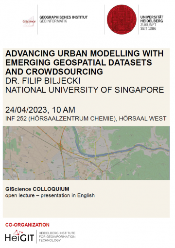
Upcoming GIScience Colloquium: Advancing urban modelling with emerging geospatial datasets and crowdsourcing
HeiGIT is proud to be co-organizing the upcoming GIScience colloquium, “Advancing urban modelling with emerging geospatial datasets and crowdsourcing” by Dr. Filip Biljecki of the National University of Singapore The colloquium will take place in the Hörsaalzentrum Chemie, Hörsaal West, INF … Read More
Launch: A New Online Mapping Application Helps UndercoverEisAgenten on the Trail of Permafrost
The UndercoverEisAgenten team have developed a new online mapping application to monitor permafrost thaw. From now on, interested citizen scientists can directly contribute online to collect reliable and up-to-date data on the thawing of Arctic permafrost landscapes- and thus improve … Read More
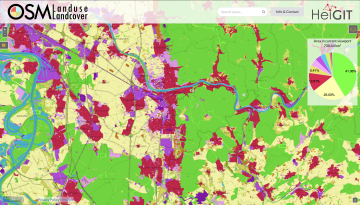
Functionality Update for OSM Landuse Landcover
We are pleased to announce that https://osmlanduse.org has received a functionality update. Thanks to the cooperation of GIScience and HeiGIT under the IDEAL-VGI project, our researchers were able to add a number of new features to the interactive map. The … Read More
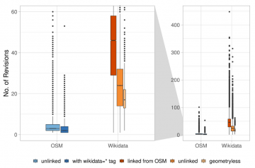
HeiGIT and GIScience Contributions to Last Year’s Conference-athon
Featured Figure: Object history revisions from Alishiba Dsouza of the University of Bonn, GIScience’s Moritz Schott and Prof. Dr. Sven Lautenbach delivered the academic track talk, “Comparative Integration Potential Analyses of OSM and Wikidata – the Case Study of Railway Stations” … Read More
Activation of the Disaster Portal for the earthquake in Türkiye/Syria
During catastrophic events such as the recent Türkiye/Syria earthquake, the road infrastructure in the affected area is often widely interrupted and accessibility varies over time. In spite of this, it is imperative to quickly provide assistance to the affected people. … Read More
HeiGIT to hold hands-on workshop about OSM data quality at FOSSGIS Berlin 15.-18.03.2023
HeiGIT will present its software “ohsome quality analyst” (OQT) at the FOSSGIS Conference in Berlin this week. In the demo session, Benjamin Herfort will show the numerous possibilities of the tool and how everyone can use OQT to evaluate completeness, … Read More
HeiGIT, DLR & GRC’s Cooperation Workshop February 27-28 in Berlin
The German Red Cross (GRC) has been working with the Heidelberg Institute for Geoinformation Technology (HeiGIT gGmbH) and the German Aerospace Center (DLR) for several years to bridge the gap between research and practice by identifying needs and developing technological … Read More