In 2020, the Humanitarian OpenStreetMap Team (HOT) received funding from seven donors through TED’s Audacious Project. This has accelerated HOT’s ambition to map an area home to one billion people. HOT is working to add places at high risk of … Read More
Blog
Ein Jahr WebApp „meinGrün“ – finale Befragung und Ergebnispräsentation
Im Juni 2020 haben wir mit unseren Partnern aus dem meinGrün Projekt die gleichnamige WebApp gestartet. Nun sind die Nutzenden in Dresden und Heidelberg aufgerufen, sich ein letztes Mal an einer Befragung zu beteiligen und so Hinweise für die mögliche … Read More
World Refugee Day: Mapathon by CartONG
Whether you are a beginner or an advanced mapper, or just curious to learn more about why mapping is so important for humanitarian work, join us on 21 June. Support the mapping of refugee locations on World Refugee Day. It … Read More
Openrouteservice for complex route optimization in new QGIS extension by Regionalverband Ruhr
Openrouteservice für komplexe Routenoptimierung in neuer QGIS-Erweiterung des Regionalverband Ruhr Der Regionalverband Ruhr (Team 9-2 Geodaten-Technik) hat mit einer neuen QGIS-Erweiterung das Potenzial von openrouteservice (ORS) von HeiGIT genutzt und eine weitere Anwendungsmöglichkeit für den ORS geschaffen: Das Tool “Verortung … Read More
HeiGIT und das Deutsche Rote Kreuz beim Digitaltag 2021
Am 18.06.2021 findet der Bundesweite Digitaltag 2021 der Initiative „Digital für alle“ statt. Der Digitaltag ist eine Plattform, auf der digitale Projekte und Aktionen aus der Zivilgesellschaft vorgestellt werden und das Thema Digitalisierung von verschiedenen Seiten beleuchtet wird. Mit dem … Read More

AGILE best short paper award nominees
We are happy to announce that two of our papers have been shortlisted as candidates for the best short paper award at the AGILE 2021 conference : Detecting OpenStreetMap missing buildings by transferring pre-trained deep neural networks Jan Pisl, Hao … Read More
GIScience and HeiGIT contributions to AGILE 2021 conference
The AGILE 2021 conference is taking place this week. It is the the 24rd AGILE conference on GIScience. AGILE is the Association of Geographic Information Laboratories in Europe and the 2021 conference is for the first time held as a … Read More
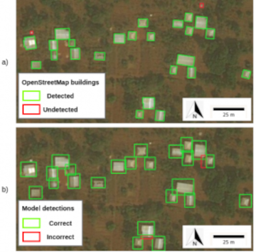
Automatic building detection with ohsome2label and Tensorflow
Accurate and complete geographic data of human settlement is crucial for humanitarian aid and disaster response. OpenStreetMap (OSM) can serve as a valuable source, especially for global south countries where buildings are largely unmapped. In a previous blog, we introduced … Read More
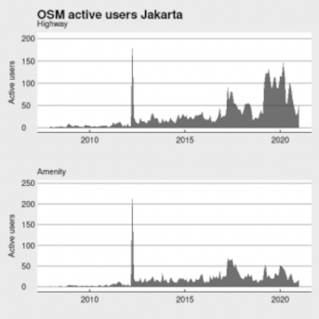
Becoming ohsome in R – analysis of the completeness of the road network and health sites in Jakarta
Data quality is an important issue then performing analysis based on OpenStreetMap data. We have recently demonstrated how the effects of the 2013 flood in Jakarta on the accessibility of hospitals and clinics could be analyzed based on network analysis … Read More
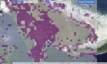
The ohsome quality analyst goes public on Github with new release 0.3.0
The ohsome quality analyst (short: OQT) has been introduced at the beginning of this year and today we are proud to announce two updates. First, we released the new version 0.3.0 which includes new OSM layers and a brand new … Read More
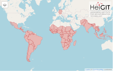
All countries of Central and South America now on Open Healthcare Access Map
After Sub-Saharan Africa and South and Southeast Asia we have now published all countries of Central and South America on the Open Healthcare Access Map. The web application is available here: https://apps.heigit.org/healthcare_access/. Please note that this is still a prototype … Read More
ohsomeHeX provides access to OSM feature history
Did you ever wonder how your city was mapped over time, how geometries were changed and refined, how mistakes were added and corrected again? Then read on: ohsomeHex has a great new feature for you – the individual object’s zoom-in-history-view. … Read More
Third International Mapathon on Mon 17.05.2021 by disastermappers heidelberg, MAMAPA, CartONG, HuMap and OSM Ghana
Dear mappers, on Monday 17.5.2021, 18.00pm a third international mapathon together with disastermappers heidelberg, MAMAPA, CartONG, HuMap and OSM Ghana will take place, which will give you some insights in mapping for humanitarian purposes from the perspective of different organizations … Read More
Detecting OpenStreetMap missing buildings by transferring pre-trained deep neural networks
Recently, a new research paper “Detecting OpenStreetMap missing buildings by transferring pre-trained deep neural networks” (Pisl, J., Li, H., Herfort, B., Lautenbach, S., Zipf, A. 2021) has been accepted at the the 24th AGILE conference 2021. The conference will take … Read More
Deriving indicators for Points of Interest and analyzing mixed activities in urban areas
We are pleased that our research paper “Deriving indicators for Points of Interest and analyzing mixed activities in urban areas” (Ullah, Lautenbach, Zipf 2021) has been accepted at the 12th International Symposium on the Digital Earth (ISDE) scheduled within the … Read More
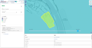
Ohsome Region of the Month Building-Information Analysis
Welcome back to our blog post series ”ohsome Region of the Month” where you can find information on potential applications of the ohsome API. If you’re new to this format you can also read some of the former blog posts … Read More
Reminder – starting THIS week: Evaluating Two-part OSM Mapathons on Mai 05 and May 11
The project “25 Mapathons“ goes into the next phase. Based on the experience of until today 17 OSM mapathons with German Red Cross (GRC) chapter and an extensive literature review on the success of mapathons, the “25 Mapathons” team has … Read More
Die Stadt Mannheim nutzt openrouteservice für die Routenplanung in ihrem Online-Stadtplan
Seit kurzem nutzt die Stadt Mannheim openrouteservice (ORS) von HeiGIT für das Routing von Fußgängern, Fahrräder, Autos, LKW und Rollstuhlfahrern im Online-Stadtplan für die breite Öffentlichkeit, d.h. die Bürger und Besucher von Mannheim. Sie können es hier verwenden: https://www.gis-mannheim.de/mannheim/index.php?bl=wms_web_grau&service=mannheim<=mod_ors Dies … Read More
UndercoverEisAgenten – “UndercoverEisAgenten” – Enabling Citizen Scientists to Monitor Permafrost Degradation
Die Folgen des Klimawandels sind besonders stark in den höheren Breiten unseres Planeten zu spüren. Die Arktis erwärmt sich derzeit überdurchschnittlich schnell. Dies führt zum Auftauen von Permafrost (dauerhaft gefrorenen Böden) mit ernsthaften Konsequenzen für das arktische Ökosystem. Etwa ein … Read More
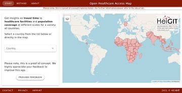
All countries of South and Southeast Asia now on Open Healthcare Access Map
It’s been a little longer than a month since we published the Open Healthcare Access Map. Last week we rolled out all countries of Sub-Saharan Africa. Today all countries of South and Southeast Asia follow. The web application is available … Read More