You genuinely enjoy developing open source Geoinformation Services used by thousands on a daily basis? You are a highly motivated Java Backend Developer and algorithm designer? And you love using and enhancing OpenStreetMap for high-performance GI services for global coverage? Then … Read More
Deutsch
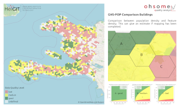
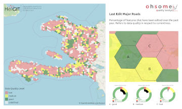
Neue Funktion im Ohsome Quality analysT: Indikator für die vollständigkeit von Gebäuden (Building Completeness Indicator)
Einführung Seit der Veröffentlichung des ohsome quality analyst (kurz OQT) im Februar letzten Jahres haben wir an der Entwicklung eines zugänglichen und dennoch leistungsfähigen Toolkits gearbeitet, das Endnutzern Einblicke in die Qualität von OpenStreetMap (OSM)-Daten bietet. Einen Überblick über die … Read More
Wie man ohsome wird, Teil 14 – Erweitertes Dashboarding
Hallo und herzlich willkommen zu unserer Serie „Wie man ohsome wird“, in der wir zeigen, wie auch Sie ohsome werden können mit ohsome API! Wenn Sie noch nicht mit der Serie bekannt sind oder eine Auffrischung brauchen, sehen Sie sich … Read More
Wie man ohsome wird, Teil 13 – Eine ohsome Art und Weise zu prüfen, ob OSM aktuell ist
Endlich zurück! Willkommen zu einem weiteren Teil unserer Wie man ohsome wird-Serie! Dieser Beitrag ist besonders, da wir die Anwendung eines Drittanbieters diskutieren, die von der ohsome API als Back-End verwendet wird, um historische OSM-Daten zu sammeln. Wenngleich diese Innovation nicht … Read More
ohsome Region des Monats: Tags zu den Themengebieten Wandern und Berge
Willkommen zurück zu einem neuen Teil der Blogserie ohsome Region des Monats! Dies wird Teil zwei unserer Posts zu Tags im Zusammenhang mit Wanderungen sein, und dieses Mal werden wir die Verbindung zwischen Benutzeraktivität und diesen Tags untersuchen. Dazu verwenden … Read More
Recent feature additions to Ohsome Quality analysT
Seit der Veröffentlichung des ohsome Quality Analyst (Short OQT) im Februar letzten Jahres haben wir an der Entwicklung eines leicht zugänglichen, aber leistungsstarken Toolkits gearbeitet, das Endbenutzern Einblicke in die Qualität der OpenStreetmap-Daten (OSM) bietet. Ein Überblick über die Funktionalitätserweiterungen, … Read More
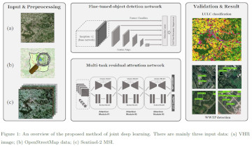
Leveraging OpenStreetMap and Multimodal Remote Sensing Data with Joint Deep Learning for Wastewater Treatment Plants Detection
Humans rely on clean water for their health, well-being, and various socio-economic activities. During the past few years, the COVID-19 pandemic has been a constant reminder of about the importance of hygiene and sanitation for public health. The most common … Read More
Räumliche Daten für die Gesellschaft – HeiGIT in die Zukunft geführt
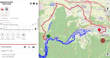
Unterführungen, Treppen und hohe Bordsteinkanten sind für Menschen mit Gehbeeinträchtigungen eine große Herausforderung. Ein maßgeschneiderter Routenplaner kann aber ihre Mobilität erhöhen, indem er Wege mit möglichst wenigen Hindernissen berechnet. Dieses Beispiel zeigt, wie Geoinformationstechnologie und Geoinformatik speziellen Gruppen in der … Read More
ohsome quality analyst (OQT) auf der FOSSGIS Konferenz am 09.03.22
Vom 9. bis zum 12. März 2022 findet die jährliche FOSSGIS Konferenz statt, die führende Konferenz für Freie und Open Source Software für Geoinformationssysteme und Open Data im deutschsprachigen Raum. HeiGIT wird dabei am 09.03. um 16:30–16:50 Bühne 2 ONLINE … Read More
How to become ohsome part 11 – counting contributions
Hello and welcome back to the How to become ohsome-blog series! We hope the new year started off well for you! If you’re new to the series, you should read our other posts in the series, as well as the … Read More
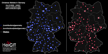
How to become ohsome part 10 – ohsome holiday contributions
Welcome back to our blog post series How to become ohsome, where you get short and simple explanations on how you can become ohsome yourself! This time, it’s all about our new endpoints, which enable you to track which contributions … Read More
United Nations World Data Forum Blog on Healthcare Accessibility Map
In the context of the United Nations World Data Forum 2021 organised by the United Nations Statistics Division and UN member states a series of blogposts has been published by UNSTATS. Among them is one by Alexander Zipf about improving … Read More
HGG Vortrag: Digitale Geographie im Katastrophenmanagement
Einladung Vortrag Online: Dienstag, 14. Dezember 2021, 19:15 Uhr Melanie Eckle-Elze, Benjamin Herfort, Dr. Carolin Klonner Digitale Geographie im Katastrophenmanagement Klimawandel, Bevölkerungswachstum, Verstädterung und weitere zunehmende Landnutzungsveränderungen führen dazu, dass immer mehr Menschen in Risikogebieten leben. Um die vorhandenen Risiken … Read More
HeiGIT and GIScience at Virtual Conference of the Red Cross Red Crescent Urban Collaboration Platform 2021
On Friday, November 26th, Dr. Carolin Klonner (GIScience Research Group) and Melanie Eckle-Elze (HeiGIT) will be supporting the Urban Context Unit of German Red Cross (GRC) in the “Data and Digitalisation in Urban Humanitarian Action” session at the Virtual Conference … Read More
FOSS4G 2021 Videos with HeiGIT contributions online – OSM data quality and MapSwipe
Recently videos with our contributions by HeiGIT to the FOSS4G conference were put online. Did you miss the event? Now you can watch whenever you like 🙂 Benni by HeiGIT explains who to use the ohsome.org framework to develop an … Read More
ohsome Region of the Month – crop tagging
Hello and welcome back to another blog post of the ohsome Region of the Month series where you can learn about potential use cases of the ohsome API. This month we were be looking at the crop tag and tried … Read More
meinGrün, Tradur und SocialMedia2Traffic bei der mFUND Konferenz 2021
Letzte Woche konnten wir bei der digitalen mFUND Konferenz drei unserer Projekte einem interessierten Publikum vorstellen. Im Fachforum “Die „15-Minuten-Stadt“ datenbasiert ermöglichen” haben wir gezeigt, wie die meinGrün App, das meinGrün Webportal und die angegliederten Dienste Städte dabei unterstützen könnten, … Read More
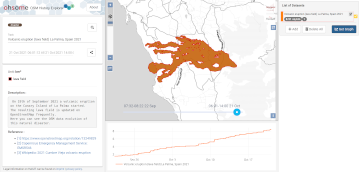
2021 Volcanic Eruption in La Palma (Spain) continues – Explore the temporal changes of the Lava Field in OpenStreetMap on ohsomeHeX
On the 19th of September 2021 a volcanic eruption on the Canary Island of La Palma started. Since then the resulting lava field is constantly growing and continues its destructive expansion. According to an article in the spanish newspaper El … Read More
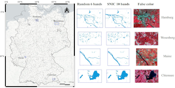
Automatic mapping of national surface water with OpenStreetMap and Sentinel-2 MSI data using deep learning
Large-scale mapping activities can benefit from the vastly increasing availability of earth observation (EO) data, especially when combined with volunteered geographical information (VGI) using machine learning (ML). High-resolution maps of inland surface water bodies are important for water supply and … Read More
HeiGIT and MapAction at FOSS4G 2021: Using the ohsome quality analyst to support humanitarian mapping
Last week, the annual conference FOSS4G (Free and Open Source Software for Geospatial) has been taken place online. The conference is organized by The Open Source Geospatial Foundation (OSGeo) and attracts over 1000 developers, users, decision-makers and observers from a … Read More