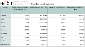
The ohsome region of the month blog post series is back and since it’s summer this time we’re taking you to the coast. Before that happens, if this is your first blog post of this format you might want to … Read More
Deutsch
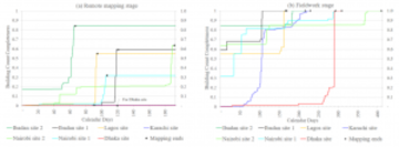
OSM data quality analysis for different stages of the mapping process
Slums are an important operational area for humanitarian organisations: Because of provisional housing, poor sanitation and difficult socio-political circumstances offers of help from such organisations are important and often necessary. For such deployments, humanitarian actors rely heavily on Volunteered Geographic … Read More
Ein Jahr WebApp „meinGrün“ – finale Befragung und Ergebnispräsentation
Im Juni 2020 haben wir mit unseren Partnern aus dem meinGrün Projekt die gleichnamige WebApp gestartet. Nun sind die Nutzenden in Dresden und Heidelberg aufgerufen, sich ein letztes Mal an einer Befragung zu beteiligen und so Hinweise für die mögliche … Read More
Openrouteservice for complex route optimization in new QGIS extension by Regionalverband Ruhr
Openrouteservice für komplexe Routenoptimierung in neuer QGIS-Erweiterung des Regionalverband Ruhr Der Regionalverband Ruhr (Team 9-2 Geodaten-Technik) hat mit einer neuen QGIS-Erweiterung das Potenzial von openrouteservice (ORS) von HeiGIT genutzt und eine weitere Anwendungsmöglichkeit für den ORS geschaffen: Das Tool “Verortung … Read More
The ohsome quality analyst goes public on Github with new release 0.3.0
The ohsome quality analyst (short: OQT) has been introduced at the beginning of this year and today we are proud to announce two updates. First, we released the new version 0.3.0 which includes new OSM layers and a brand new … Read More
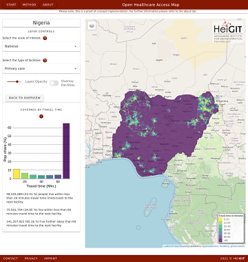
All countries of Central and South America now on Open Healthcare Access Map
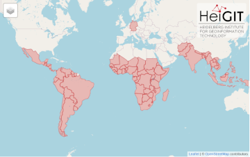
After Sub-Saharan Africa and South and Southeast Asia we have now published all countries of Central and South America on the Open Healthcare Access Map. The web application is available here: https://apps.heigit.org/healthcare_access/. Please note that this is still a prototype … Read More
Third International Mapathon on Mon 17.05.2021 by disastermappers heidelberg, MAMAPA, CartONG, HuMap and OSM Ghana
Dear mappers, on Monday 17.5.2021, 18.00pm a third international mapathon together with disastermappers heidelberg, MAMAPA, CartONG, HuMap and OSM Ghana will take place, which will give you some insights in mapping for humanitarian purposes from the perspective of different organizations … Read More
Ohsome Region of the Month Building-Information Analysis
Welcome back to our blog post series ”ohsome Region of the Month” where you can find information on potential applications of the ohsome API. If you’re new to this format you can also read some of the former blog posts … Read More
Reminder – starting THIS week: Evaluating Two-part OSM Mapathons on Mai 05 and May 11
The project “25 Mapathons“ goes into the next phase. Based on the experience of until today 17 OSM mapathons with German Red Cross (GRC) chapter and an extensive literature review on the success of mapathons, the “25 Mapathons” team has … Read More
Die Stadt Mannheim nutzt openrouteservice für die Routenplanung in ihrem Online-Stadtplan
Seit kurzem nutzt die Stadt Mannheim openrouteservice (ORS) von HeiGIT für das Routing von Fußgängern, Fahrräder, Autos, LKW und Rollstuhlfahrern im Online-Stadtplan für die breite Öffentlichkeit, d.h. die Bürger und Besucher von Mannheim. Sie können es hier verwenden: https://www.gis-mannheim.de/mannheim/index.php?bl=wms_web_grau&service=mannheim<=mod_ors Dies … Read More
All countries of South and Southeast Asia now on Open Healthcare Access Map
It’s been a little longer than a month since we published the Open Healthcare Access Map. Last week we rolled out all countries of Sub-Saharan Africa. Today all countries of South and Southeast Asia follow. The web application is available … Read More
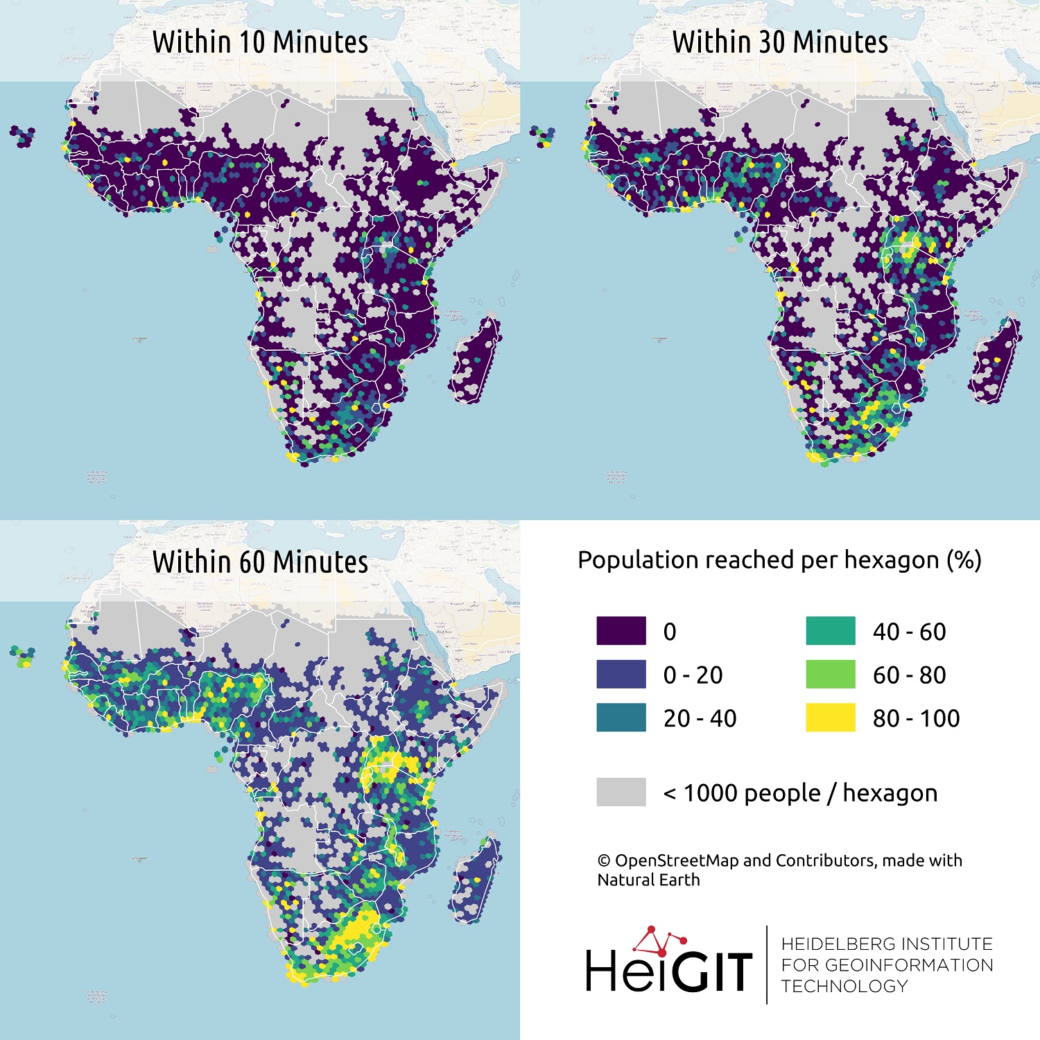
All countries of Sub-Saharan Africa now in Open Healthcare Access Map
Last month we started the Open Healthcare Access Map. Initially, only a few countries were featured. Gradually, more countries and regions are now being added. Today we release all countries of Sub-Saharan Africa. The web application is available here: https://apps.heigit.org/healthcare_access/. … Read More
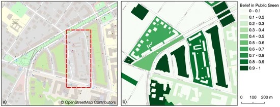
Mapping Public Urban Green Spaces Based on OpenStreetMap and Sentinel-2 Imagery Using Belief Functions
Public urban green spaces are important for the urban quality of life. Still, comprehensive open data sets on urban green spaces are not available for most cities. As open and globally available data sets, the potential of Sentinel-2 satellite imagery … Read More
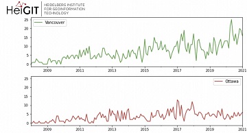
Ohsome Green Region of the Month
Welcome back to the ohsome region of the month format where you can learn and get inspiration about potential applications of the ohsome API. This time we looked at forest-related information in four different Canadian regions looking for the green … Read More
HeiGIT und DRK veröffentlichen weiteres Trainingsmaterial zu Mapathons
Gemeinsam mit dem Deutschen Roten Kreuz (DRK) hat das HeiGIT heute das Dokument “Die häufigsten Fehler beim „mappen“ mit dem iD-Editor & deren Lösung” veröffentlicht. Das Dokument ist komplementär zum Handbuch zur Veranstaltung von Mapathons, welches bereits 2020 veröffentlicht wurde. … Read More
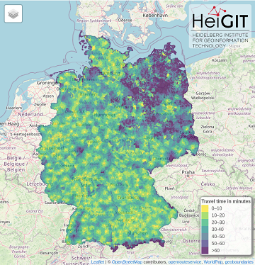
German Mass Vaccination Sites in Open Healthcare Access Map
Last week we introduced Open Healthcare Access Map. Our new web application for interactively sharing results of accessibility estimates based on OpenStreetMap healthcare facilities and openrouteservice isochrones. A new update now shows motorized accessibility estimates of mass vaccination sites in … Read More
ohsome-py: Python Package for OSM history analytics published
As a little Easter present, we published the first version of the ohsome-py Python package today. ohsome-py helps you extract and analyse OpenStreetMap history data using the ohsome API and Python. It handles queries to the ohsome API and converts … Read More
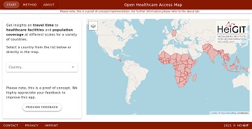
Introducing the Open Healthcare Access Map
Open Healthcare Access Map is a new web application by HeiGIT to provide insights into healthcare supply on different spatial scales for many countries worldwide. The web application is available here: https://apps.heigit.org/healthcare_access/. Please note that this is a prototype and … Read More
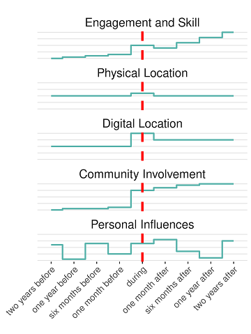
New publication on the Impact of Community Happenings in OpenStreetMap
Online knowledge projects such as OpenStreetMap (OSM) and Wikipedia have gained high importance, trust and even economic value. These projects and their content are maintained and enhanced by online communities that evolve around them. Yet, these communities and their members … Read More
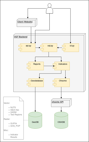
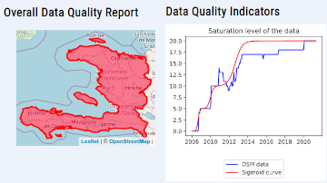
Behind the scenes of the ohsome quality analyst (OQT)
The #ohsome quality analyst (short: OQT) has been online and accessible through its web-interface now for quite some weeks already (see the introductory blog post as a reference). The website is not the only access point to the OQT though. … Read More