Sie lieben Open-Source-Geoinformationsdienste zu entwickeln, die täglich von Tausenden genutzt werden? Sie sind ein hochmotivierter Java Backend-Entwickler und Algorithmen-Designer? Und Sie wollen OpenStreetMap für leistungsstarke GI-Dienste mit globaler Abdeckung einsetzen und verbessern? Dann haben wir vielleicht einen passenden und interessanten … Read More
Deutsch
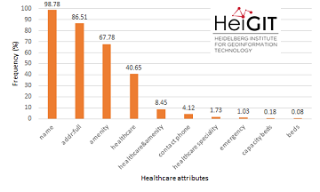
Insights into OpenStreetMap healthcare attributes in India over time
Last November, we covered the recent increase of healthcare related objects in OpenStreetMap (OSM) in India. In less than a year, the amount of facilities has increased from 6.956 to 48.101. This is mainly due to an import run by … Read More

Projektstart von SocialMedia2Traffic – Ableitung von Verkehrsinformationen aus Social–Media-Daten
Aktuelle Verkehrsinformationen sind die Voraussetzung für Navigations-Lösungen, um die beste Route und Fahrzeit zu bestimmen. Es gibt jedoch keine frei verfügbaren Verkehrsinformationen auf weltweiter- und Bundesebene. „SocialMedia2Traffic nutzt frei verfügbare Daten aus sozialen Medien wie zum Beispiel Twitter-Nachrichten“, sagt Prof. … Read More
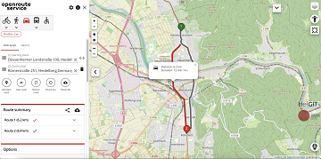
A fresh new ORS maps client
We are happy to announce that the new openrouteservice maps client has been finished and released. It is an open source route planner with plenty of features for car, heavy vehicles, hiking, cycling and wheelchair, designed to be mobile friendly … Read More
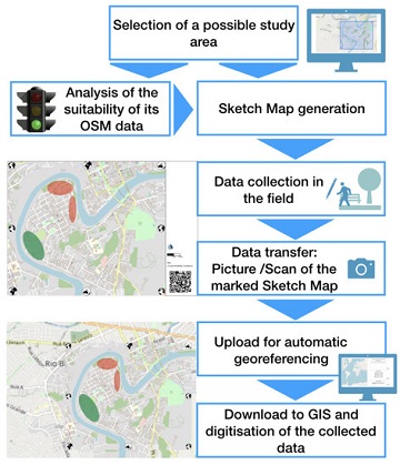
New paper published about the OSM Sketch Map Tool
The Sketch Map Tool supports participatory mapping approaches and risk communication. An new paper presents the different functionalities of the tool. OSM data quality can be evaluated regarding the fitness for the sketch-map-approach. Based on the great idea of Field … Read More
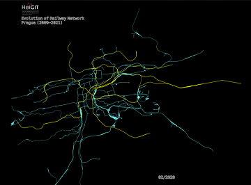
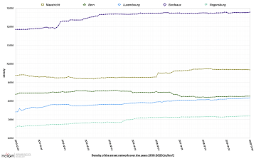
An ohsome Railway Network Visualization and Analysis
Welcome back to another #ohsome blog post written by our awesome student assistent Sarah! This time we will look at the completeness of railway network data of one specific city in OpenStreetMap, as well as its development. For this we … Read More
AUF DIREKTEM WEG ZUR CORONA-IMPFUNG – Meldung der Universität Heidelberg
Die Universität Heidelberg berichtet aktuell über impfzentrum.openrouteservice.org NEUER ROUTENPLANER ERMITTELT DEUTSCHLANDWEIT DIE SCHNELLSTE ROUTE ZUM NÄCHSTEN IMPFZENTRUM Wo kann ich mich gegen das Coronavirus impfen lassen und wie komme ich dorthin? Diese Frage beantwortet ein von Geoinformatikern der Universität Heidelberg … Read More
Introducing the Ohsome Quality analysT (OQT)
The Ohsome Quality analysT (short OQT) is the name of a new software implemented by HeiGIT that is based on the #ohsome framework. Its main purpose is to compute quality estimations on OpenStreetMap (OSM) data. Any end user such as … Read More
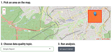
ohsome street network analysis part 1
Here we go again: The first #ohsome blog post of 2021. This time, one of our new student assistants Sarah was dealing with street networks and their quality in order to find out which of the selected regions has the … Read More
LandSense Horizon 2020 A Citizen Observatory and Innovation Marketplace for Land Use and Land Cover Monitoring, project successful finished
The Horizon 2020 LandSense project was concluded successful. Please find a selection of the produced publications and deliverables here. The project has enabled our group to pursue quality aspects of voluntarily collected geo information data and to ramp up efforts … Read More
Disastermappers Heidelberg International Mapathon on December 8th
On December 8th at 6.30 pm the next international mapathon organized by the disastermappers heidelberg takes place! This time we map together with MAMAPA, an integration project for migrants and refugees from Mannheim, CartONG, LECLARA Larabanga and OSM Ghana. We … Read More
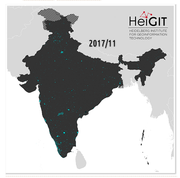
Recent changes to OpenStreetMap healthcare infrastructure in India
India accounts for nearly 18% of the worlds population. The country is also one of the main carrier of the worlds disease burden. Despite the general increase in life expectancy and decreasing mortality due to communicable diseases and malnutrition in … Read More
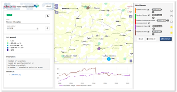
Neu: Globale OSM History Analysen mit ohsomeHeX v1.0
Erhalten Sie mit ohsomeHeX wertvolle Einblicke in die Qualität und den Entwicklungsprozess von OpenStreetMap-Daten! (see for english version here) Das HeiGIT Big Data Team freut sich zur Exploration der Veränderungen der globalen Daten in OpenStreetMap nun eine Version 1.0 von … Read More
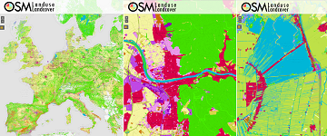
OSMlanduse European Union validation effort EuroSDR conference 11/24/2020
During the EuroSDR workshop we will present our OSMlanduse product (earlier post) to the land use (LU) and land cover community (LC) and highlight class accuracies and a benchmark comparison towards existing national authoritative products. Accuracy estimated to be presented … Read More
Mapathons im Rahmen der OSM Geography Awareness Week – OSM GeoWeek
Kooperation ist in der Humanitären Hilfe oft der Schlüssel, um Menschen in Not schnell und effizient helfen zu können. Das gilt insbesondere beim Austausch von Informationen und Kartenmaterial. Besonders herausfordernd sind die Situationen für Humanitäre Organisationen in Gebieten, von denen … Read More
New paper published: Participatory Mapping and Visualization of Local Knowledge: An Example from Eberbach, Germany
Flooded parking area in Eberbach in January 2019 (Picture: C.Klonner) Worldwide, more and more people are affected by flooding. Local knowledge provides a valuable source of information for disaster risk reduction. We present an approach for visualizing and formalizing this … Read More
Regional Variations of Context-based Association Rules in OpenStreetMap
As a user‐generated map of the whole world, OpenStreetMap (OSM) provides valuable information about the natural and built environment. However, the spatial heterogeneity of the data due to cultural differences and the spatially varying mapping process makes the extraction of … Read More
Optimal ans Ziel: Routing-Dienste auf Basis nutzergenerierter Geodaten
Ein neues Buch gibt in einem Buchkapitel einen Überblick der vielfältigen Aktivitäten von HeiGIT und GIScience im Bereich Routenplanung und Navigation. Neben Grundlagen (wie schnelle Routing-Algorithmen) zur Umsetzung werden vor allem diverse Anwendungsbeispiele für flexible Routing-Dienste in Spezialanwendungen vorgestellt. Hierzu … Read More
OSMlanduse wird auf Geonet.MRN Meetup zu Flächennutzung und Flächenmanagement vorgestellt: Donnerstag 29.10.2020, 16:30
Am am 29.10.20, 16:30 Uhr veranstaltet das Netzwerk Geoinformation der Metropolregion Rhein-Neckar GeoNet.MRN zum Thema: Flächennutzung und Flächenmanagement: Ein Geoinformation Meetup Teilnahme: Kostenlos und ohne Anmeldung mit Teams unter diesem Link. Themen des Meetups sind die Online-Beteiligung von Kommunen, Bürgern … Read More