Today (1st July 2020) marks the first birthday of HeiGIT gGmbH! Over this first year, HeiGIT has been involved a large number of events, projects, publications, and press coverage. Founded on the 1st July 2019, HeiGIT is a non-for-profit organisation … Read More
Deutsch
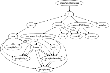
Sphinx is ohsome – new documentation of the ohsome API
What does the tool behind the recently published documentation of the ohsome API have in common with a statue made of stones in Egypt? – Apart from the name, both are of course awesome (and now also ohsome). As previously … Read More
Humanitarian OpenStreetMap Team has been selected by the Audacious Project
The Humanitarian OpenStreetMap Team (HOT) has announced major financial support from the Audacious Project, which will be provided over the next five years. HOT aims to use this funding to grow OpenStreetMap (OSM) communities in 94 countries. By engaging one … Read More

Exploring OSM for healthcare access analysis in Sub-Saharan Africa
Using hospital locations and the ORS Isochrone service, we have created a method for comparing physical access to healthcare in Sub-Saharan Africa. Hospital locations were derived from OpenStreetMap and compared against another free available dataset. Results indicate strong similarity in … Read More

ohsome API 1.0 is here
As we’ve announced it in a previous post, the Open Source release 1.0 of the ohsome API has finally arrived. As a reminder, or for those of you that hear “ohsome” for the first time, the aim of the ohsome … Read More
Announcing release 1.0 of ohsome API
Big news from the ohsome team: the release 1.0 of one of our major services, the ohsome API for ohsome OpenStreetMap History Analytics, is on the doorstep. We are bringing three major advancements along with this version. The first one … Read More
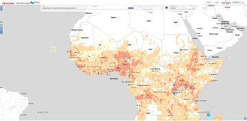
Analysing OSM Completeness of health facilities in Sub-Sahara Africa in ohsomeHeX
A new map in ohsomeHeX provides an overview of areas in Sub-Sahara Africa where information on health facilities is still missing in OpenStreetMap (OSM). The completeness of OSM is measured by comparing to a reference dataset on public health facilities … Read More
Colloquium Talk about healthsites.io: Building a baseline of health facility data in OpenStreetMap by M. Herringer
We are happy to invited to the presentation in the GIScience HD colloquium. Everybody interested is invited to join the presentations and the discussion afterwards. Building a baseline of health facility data in OpenStreetMap Markus Herringer, healthsites.io, Amsterdam, NL – … Read More

GIScience Contributions to the 2019 State of the Map Academic Track proceedings
Recently the SOTM 2019 Heidelberg Academic Track Proceedings have been published. GIScience Research Group Heidelberg and HeiGIT contributed several talks and posters. Below you can find an overview. Contact us if you are interested in further details on ongoing research. … Read More
ohsome presentation in Malta at the 3rd International Workshop on Spatial Data Quality
Around 55 participants gathered in Malta for the 3rd International Workshop on Spatial Data Quality 2020 from 28th to 29th of January. Among national mapping agencies, software providers and standardization organizations, HeiGIT had the opportunity to present its ohsome – … Read More
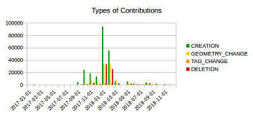
Mapping Rohingya Refugee Camps in Bangladesh – An Analysis Using the OSHDB API
Humanitarian mapping activations show increasing numbers of contribution. This blog post illustrates the specific potential of the OSHDB API [1] for detailed analyses of such activations by means of a case study. The examined area is Cox’s Bazar in Southeast … Read More
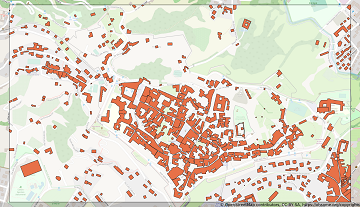
Becoming ohsome is simple: Adding support of simple feature types to the ohsome API
It’s been a while, since we have published the last blog post about the awesome ohsome platform, but don’t worry, there’s always something happening of course in the spatial analytics team of HeiGIT. So here we are, back on track … Read More
Tools for Disaster Risk Reduction by HeiGIT – Celebrating the International Day for Disaster Risk Reduction
Today we celebrate the International Day for #DisasterRiskReduction. HeiGIT offers a growing set of tools and services that support humanitarian aid during and before disasters. Examples include work in the context of the Missing Maps initiative, like conceptualising and extending … Read More
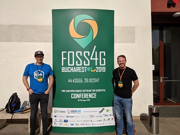
Recap of HeiGIT @ FOSS4G 2019
First of all, thanks to everybody who attended our ohsome lab at last weeks FOSS4G in Bucharest. Even though there were eleven (!) tracks running in parallel, and our lab was not in the same location as the program track, … Read More
HeiGIT presents ohsome Lab at FOSS4G 2019 Bucharest
This week, the annual conference FOSS4G (Free and Open Source Software for Geospatial) is taking place in Bucharest, Romania. The conference is organized by The Open Source Geospatial Foundation (OSGeo) and attracts over 1000 professionals from industry and academia each … Read More
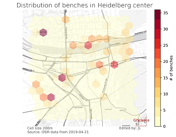
meinGrün @roadto_festival: What OSM tells us about urban green space features
Where is the next shaded bench to escape the burning heat? Where can I play soccer within the city and later on have a barbecue with my friends? All of these questions require information about features of urban green spaces. … Read More
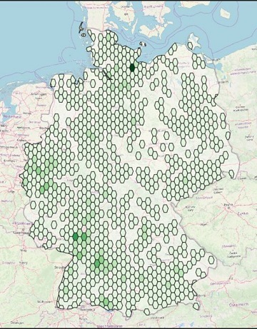
Farm Shops are ohsome
Welcome back to another ohsome blog post. Today, we will present the results of a recent analysis performed by our student assistant Jascha, who took a look at the distribution and development of farm shops (in German: Hofläden) at different … Read More
Successfull PhD Defence by Clemens Jacobs on Plausibility Estimation of Citizen Science Observations for Biodiversity
Last week Dr. Clemens Jacobs successfully defended his PhD about methods for assessing the data quality of citizen science observations of organisms. Congratulations, well done!!! We wish all the very best for the future! The research aimed at using geographic … Read More
Disaster Risk Reduction, OpenStreetMap and Missing Maps at Global Platform 2019
Global Platform 2019 in Geneva Creating maps helps humanity. Drawing maps together with communities is crucial for effective risk reduction interventions, ensuring no one is left behind. The progress of the implementation of the targets set by the Sendai … Read More
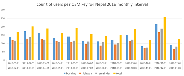
How to become ohsome part 5: Measuring numbers of users editing different OSM features
Besides dealing with a snake, making quality assessments, or generating comparable statistics, one needs to know how to handle the whole functionality provided by the ohsome API to really become ohsome. And to achieve exactly that, this blog presents the … Read More

