
The AGILE 2021 conference is taking place this week. It is the the 24rd AGILE conference on GIScience. AGILE is the Association of Geographic Information Laboratories in Europe and the 2021 conference is for the first time held as a … Read More
Deutsch
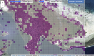
Automatic building detection with ohsome2label and Tensorflow
Accurate and complete geographic data of human settlement is crucial for humanitarian aid and disaster response. OpenStreetMap (OSM) can serve as a valuable source, especially for global south countries where buildings are largely unmapped. In a previous blog, we introduced … Read More
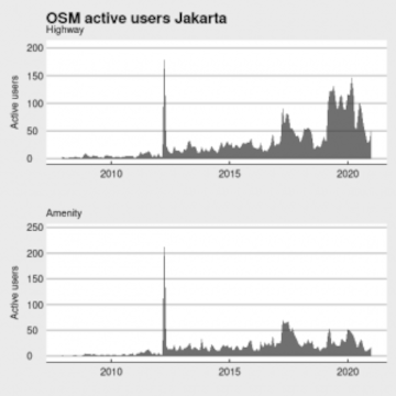
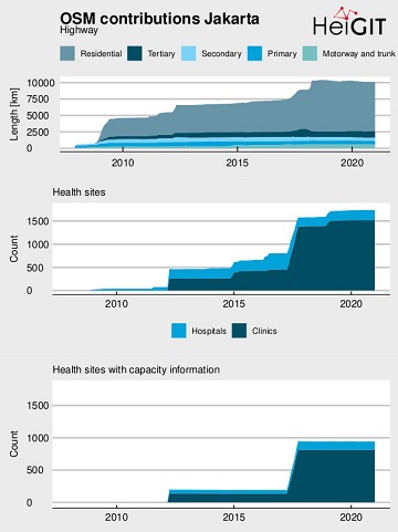
Becoming ohsome in R – analysis of the completeness of the road network and health sites in Jakarta
Data quality is an important issue then performing analysis based on OpenStreetMap data. We have recently demonstrated how the effects of the 2013 flood in Jakarta on the accessibility of hospitals and clinics could be analyzed based on network analysis … Read More
The ohsome quality analyst goes public on Github with new release 0.3.0
The ohsome quality analyst (short: OQT) has been introduced at the beginning of this year and today we are proud to announce two updates. First, we released the new version 0.3.0 which includes new OSM layers and a brand new … Read More
ohsomeHeX provides access to OSM feature history
Did you ever wonder how your city was mapped over time, how geometries were changed and refined, how mistakes were added and corrected again? Then read on: ohsomeHex has a great new feature for you – the individual object’s zoom-in-history-view. … Read More
Ohsome Region of the Month Building-Information Analysis
Welcome back to our blog post series ”ohsome Region of the Month” where you can find information on potential applications of the ohsome API. If you’re new to this format you can also read some of the former blog posts … Read More
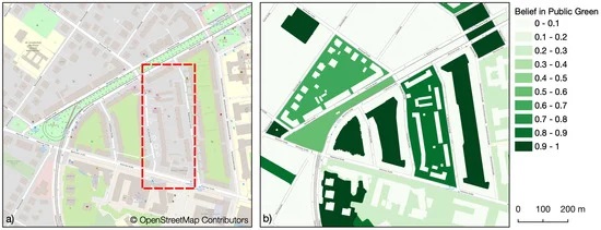
Mapping Public Urban Green Spaces Based on OpenStreetMap and Sentinel-2 Imagery Using Belief Functions
Public urban green spaces are important for the urban quality of life. Still, comprehensive open data sets on urban green spaces are not available for most cities. As open and globally available data sets, the potential of Sentinel-2 satellite imagery … Read More
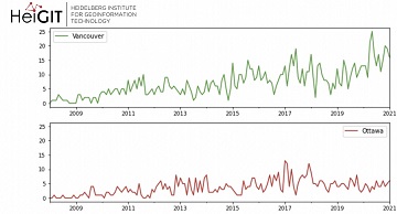
Ohsome Green Region of the Month
Welcome back to the ohsome region of the month format where you can learn and get inspiration about potential applications of the ohsome API. This time we looked at forest-related information in four different Canadian regions looking for the green … Read More
Towards a framework for the analysis of local OSM contributions
Volunteered Geographic Information (VGI) such as OpenStreetMap (OSM) is often defined as the collaborative acquisition of geographic information and local knowledge by volunteers, amateurs or professionals (Goodchild, 2007). The increasing availability and importance of local data in OSM is largely … Read More
ohsome-py: Python Package for OSM history analytics published
As a little Easter present, we published the first version of the ohsome-py Python package today. ohsome-py helps you extract and analyse OpenStreetMap history data using the ohsome API and Python. It handles queries to the ohsome API and converts … Read More
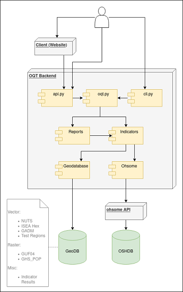
Behind the scenes of the ohsome quality analyst (OQT)
The #ohsome quality analyst (short: OQT) has been online and accessible through its web-interface now for quite some weeks already (see the introductory blog post as a reference). The website is not the only access point to the OQT though. … Read More
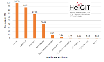
Insights into OpenStreetMap healthcare attributes in India over time
Last November, we covered the recent increase of healthcare related objects in OpenStreetMap (OSM) in India. In less than a year, the amount of facilities has increased from 6.956 to 48.101. This is mainly due to an import run by … Read More
Flood Impact Assessment on Road Network and Healthcare Access at the example of Jakarta, Indonesia
Extreme natural events create catastrophic situations for cities and their populations. Due to climate change and anthropogenic activities, the number and intensity of these events has steadily increased at the global scale. Floods are the most common natural disaster worldwide, … Read More
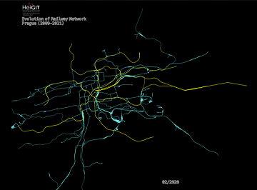
An ohsome Railway Network Visualization and Analysis
Welcome back to another #ohsome blog post written by our awesome student assistent Sarah! This time we will look at the completeness of railway network data of one specific city in OpenStreetMap, as well as its development. For this we … Read More
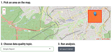
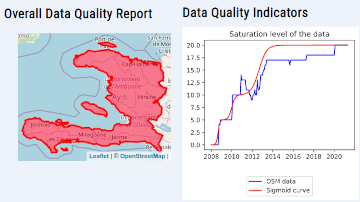
Introducing the Ohsome Quality analysT (OQT)
The Ohsome Quality analysT (short OQT) is the name of a new software implemented by HeiGIT that is based on the #ohsome framework. Its main purpose is to compute quality estimations on OpenStreetMap (OSM) data. Any end user such as … Read More
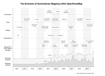
The evolution of humanitarian mapping within the OpenStreetMap community
In the past 10 years, the collaborative maps of OpenStreetMap (OSM) have been used to support humanitarian efforts around the world as well as to fill important data gaps for implementing major development frameworks such as the Sustainable Development Goals … Read More
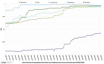
ohsome street network analysis part 2
Welcome to part 2 of the #ohsome street network analysis. If you haven’t read the first part yet, you can do so following this link. As promised, this week we are performing a simple tag completeness analysis, where we are … Read More
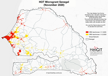
Updated OSM Healthcare in Senegal (2020)
OpenStreetMap (OSM) offers many possibilities and holds potential in the area of freely available infrastructure data for the health sector. Nevertheless, it is important to underline that the quality of the information is different in each country, since the mapping … Read More
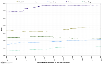
ohsome street network analysis part 1
Here we go again: The first #ohsome blog post of 2021. This time, one of our new student assistants Sarah was dealing with street networks and their quality in order to find out which of the selected regions has the … Read More
Accessibility to pharmacies in Germany with 15km Covid-19 restriction
Current lockdown regulations in Germany state that – in many but not all federal states – travel in COVID-19 hotspot regions is only allowed up to 15km distance. This has raised concerns since a 15km radius has been perceived by … Read More