According to a recent post by NASA, researchers at NASA’s Goddard Space Flight Center in Greenbelt, Maryland, calculated the time that could have been saved if ambulance drivers and other emergency responders had near-real-time information about flooded roads, using the … Read More
Deutsch

Openrouteservice v6.0 – Ganymede
We are pleased to announce the latest release of openrouteservice – version 6.0 also known as Ganymede. The main changes in this release are nestled in the backend code itself and have been performed to update the core GraphHopper library … Read More

meinGrün Vorstellung auf geoActive Heidelberg
HeiGIT|GIScience HD beteiligt sich auch dieses Jahr am Fachaustausch geoActive (28.11.2019, 12.00 – 16.00 Uhr, halle02, Heidelberg) des GeoNet.MRN. In diesem Jahr werden wir als Teil des Open Space Konzeptes den aktuellen Stand der App meinGrün vorstellen und Informationen zu … Read More
GeoNet.MRN at Smart City Expo World Congress Barcelona 2019
Last week was the Smart City Expo World Congress 2019 took place in Barcelona. Our region geoinformation network GeoNet.MRN was there with a booth presenting the members of GeoNet.MRN, among others the GIScience Research Group / HeiGIT at Heidelberg University. … Read More
Winner of the 2019 Climathon Heidelberg
Over the last few days, Heidelberg’s first climathon event took place at EMBL, which was part of the global Climathon. The event ran from 25th-27th October 2019 with a 24 hour hackathon taking place on the 26th-27th. During the 24 … Read More

Einladung zum Beta Test der meinGrün App
Beim Konsortialtreffen letzte Woche haben wir die erste Beta Version der meinGrün App fertiggestellt. Jetzt benötigen wir Grünflächen-Enthusiasten, die mit uns zusammen die App testen, um sie weiter zu verbessern. Diesen Samstag findet unser erstes Test-Event statt: WO: Volkshochschule Heidelberg … Read More
2 Days left to Register for the 1st Climathon in Heidelberg am 26.-27. Oct 2019 am EMBL mit Unterstützung von HeiGIT/GIScience Heidelberg
only a 2 days left for Pre-Registration 1st Climathon in Heidelberg am 26.-27. Oct 2019 am EMBL mit Unterstützung von HeiGIT/GIScience Heidelberg We are happy to share that GIScience Heidelberg/HeiGIT participate in the 1st Climathon in Heidelberg on Sat/Sun 26.-27. … Read More

Join us for the 1st Climathon in Heidelberg 26.-27. Oct 2019
We are happy to share that GIScience Heidelberg/HeiGIT participate in the 1st Climathon in Heidelberg on Sat/Sun 26.-27. Oct 2019 at EMBL Heidelberg with a challenge on the following topic: Boost bicycle usage through more attractive bicycle routes Identify factors … Read More
Tools for Disaster Risk Reduction by HeiGIT – Celebrating the International Day for Disaster Risk Reduction
Today we celebrate the International Day for #DisasterRiskReduction. HeiGIT offers a growing set of tools and services that support humanitarian aid during and before disasters. Examples include work in the context of the Missing Maps initiative, like conceptualising and extending … Read More
Interested in time-dependent routing?
We are delighted to invite you to join a workshop on open-source routing with time-dependent restrictions, see http://giscienceblog.uni-hd.de/2019/04/17/project-tardur-starts-open-source-routing-with-time-dependent-restrictions/. The workshop is taking place on Friday before the State of the Map conference, 20th September 2019 in Heidelberg. It is free … Read More

New ORS Jupyter example about Fleet Scheduling for Disaster Response with ORS and VROOM
Routing optimization in a humanitarian context Routing optimization generally solves the Vehicle Routing Problem (a simple example being the more widely known Traveling Salesman Problem). A more complex example would be the distribution of goods by a fleet of … Read More
meinGrün @roadto_festival: What OSM tells us about urban green space features
Where is the next shaded bench to escape the burning heat? Where can I play soccer within the city and later on have a barbecue with my friends? All of these questions require information about features of urban green spaces. … Read More
Do you need a shady route because it is too hot?
IT IS HOT! So you are looking for a more shady pedestrian route through the urban jungle? You might then prefer some routes that go through public green spaces with trees and bushes. Thank goodness we are working already on … Read More
Disaster Risk Reduction, OpenStreetMap and Missing Maps at Global Platform 2019
Global Platform 2019 in Geneva Creating maps helps humanity. Drawing maps together with communities is crucial for effective risk reduction interventions, ensuring no one is left behind. The progress of the implementation of the targets set by the Sendai … Read More
Sonniges „meinGrün“ Konsortiumstreffen in Heidelberg
Letzte Woche fand das zweite große Konsortiumstreffen im Projekt „meinGrün“ in Heidelberg statt. Zusammen mit unseren Projektpartnern vom IÖR , DLR , ISB AG , dem Institut für Kartographie der TU Dresden , Terra Concordia (mundraub.org) und Urbanista haben wir … Read More
meinGrün Umfrage: Wofür nutzen Sie städtische Grünflächen?
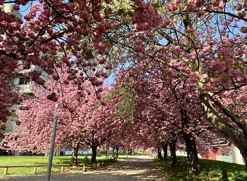
Alle Jahre wieder blühen die Kirschbäume vor unserem Institutsgebäude in voller Pracht und laden Passanten allen Alters ein zum Verweilen. Städtische Grünflächen wie diese leisten einen wichtigen Beitrag zur urbanen Lebensqualität, indem sie viele Funktionen wie Naturerfahrung, sozialen Austausch und … Read More
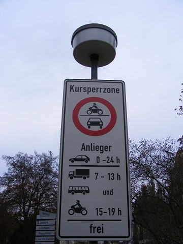
Project “TARDUR” starts: Open-source routing with time-dependent restrictions
Time-dependent restrictions and temporal road closures are so far not considered in any freely available software for route planning. Heidelberg University and the company GraphHopper aim to address this issue in their joint project “TARDUR – Temporal Access Restrictions for … Read More
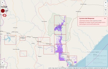
openrouteservice for Disaster Management: Response to Cyclone Idai
The Humanitarian OpenStreetMap Team (HOT) has launched an activation to support humanitarian operations responding to the impact of Cyclone Idai. These efforts were already supported by more than 1500 mappers of the global OpenStreetMap (OSM) community that contribute geodata about … Read More
Die Sendung mit der Maus: Zu Fuß durch Deutschland
Das HeiGIT unterstützt das Bundesamt für Kartographie und Geodäsie (BKG) dabei eine Frage aus der “Die Maus”-Redaktion zu beantworten: Welcher ist Deutschlands nördlichster & südlichster Ort, und wie groß ist die fußläufige Distanz dazwischen? Der Beitrag war am 23.03.2019 in … Read More